
Famous Paintings of the Catskills
Hudson River School Art Trail, New York
Walk in the footsteps of the painters who created the first great American art movement.
From Cedar Grove, The Thomas Cole National Historic Site

The Hudson River School Art Trail is a three-mile historic theme trail is part of a larger network comprised of seven sites linking the home of Thomas Cole, founder of the Hudson River School, with painting sites that inspired the work of many artists in the nineteenth century. Thomas Cole's home is now a National Historic Landmark and today provides an orientation for your exploration of the Hudson River School Art Trail.

|
|
| The home and workplace of Thomas Cole, founder of the Hudson River School of art, in Catskill, NY |
The Development of the Trail The Art Trail is currently in the initial stages of its development, which includes the creation of a brochure and web site with maps, driving and walking directions, and printed representations of the painted views to use as a comparison with today's actual views.
The Art Trail will include wayside interpretive signs including reproductions of paintings depicting that site as well as background information on the painting, the artist, and how the scene has been preserved. These wayside interpretive signs will serve as "captions on the landscape," enhancing the visitor's understanding about the Hudson River landscape and the art that it inspired.
The artist Thomas Cole made his first trip up the Hudson River to Catskill in 1825. The resulting paintings created a sensation in the nascent New York art world and launched the Hudson River School of art. These influential first paintings included a rendition of Kaaterskill Falls as well as South Lake, both of which are included in this Trail.
 |
|
| Frederic Church, Scene on Catskill Creek, 1847 |
As one example of the sites along the trail, the painting at left was painted by Frederic Church at Trail Site 3 on the Catskill Creek Just a few miles from his home, this scene inspired Thomas Cole so much, he painted it more than any other. "The painter of American scenery has indeed privileges superior to any other; all nature here is new to Art." -- Thomas Cole, Journal entry, 1835
A New Art Movement... for a New Nation
In the early years of the 19th century, the fledgling American nation was seeking a cultural identity apart from Europe and a style of art that it could call its own. A group of artists found the answer in the beauty and majesty of the natural world they encountered in the Hudson River Valley and created magnificent landscape paintings. This movement, the first in American art, became known as the Hudson River School.
|
|
||||


The Hudson River School painters believed art to be an agent of moral and spiritual transformation. In large-scale canvases of dramatic vistas with atmospheric lighting, they sought to capture a sense of the divine, envisioning the pristine American landscape as a new Garden of Eden.
The Hudson River School Art Trail pays homage to both the creative and the historical significance of the Hudson River School painters. Their work created not only an American art genre, but also a deeper appreciation for the nation's natural wonders, laying the groundwork for the environmental conservation movement and National Park System.
The Hudson River School Art Trail enables you to walk in the footsteps of Thomas Cole, Frederic Church, Asher B. Durand, Jasper Cropsey, Sanford Gifford and other pioneering American landscape artists, and appreciate their work in an entirely new way. Most of the stops on the trail are within 15 miles of Cedar Grove, The Thomas Cole National Historic Site. Located in Catskill, New York, this was the home and studio of Thomas Cole, acknowledged founder of the movement. Wear comfortable shoes, open your eyes, and prepare to be inspired
Follow the Hudson River School Art Trail to the places that stimulated a distinctly American artistic identity. Seeing the sites on the Hudson River School Art Trail will be a memorable and rewarding experience, but be prepared to give it some time as the trail stops are located over a fairly wide area. Some of the stops are easy to get to by car, while others can be reached only on foot and range from an easy walk to a fairly strenuous hike. The Trail Map and Directions will help you to plan your visits to the sites you want to see.
 |
|
| Thomas Cole, Lake with Dead Trees (Catskill), 1825 (click painting to enlarge) |
Cedar Grove - Thomas Cole National Historic Site
The Main House and Studio are open by guided tours, which are offered Friday, Saturday & Sunday, 10 am to 4 pm, from early May through late October. The grounds are open free of cost, and a small fee is charged for the tour. For detailed information about hours, admission and group tours, log on to www.thomascole.org.
Olana State Historic Site
Tours of the house are offered daily (except Mondays), 10 am to 5 pm, April through November, and on weekends and by appointment from December through March. Reservations to tour the house are highly recommended. There is a small fee per car on weekends and holidays, and a year-round fee for the guided house tour. For more information, log on to www.olana.org or call 518-828-0135.
North-South Lake Area
Your hike may require the purchase of a day-use fee at the New York State DEC's North-South Lake Campground, which is open from early May through late October. For information during the camping season, call the campground office at 518-589-5058, or call the DEC Regional Office year-round at 518-357-2234.
The Hudson River School Art Trail is a project of the Thomas Cole National Historic Site, presented in partnership with Olana, the home and workplace of Frederic Church, and with the National Park Service Rivers & Trails program, with assistance from the Greene County Tourism Promotion Department. The Trail project is funded in part by a grant from the U.S. Department of Transportation, with special thanks to Congressman John Sweeney for his support.
For more information:
The Hudson River School Art Trail is a project of Cedar Grove, The Thomas Cole National Historic Site, Spring Street, Catskill, New York 12414
Phone (518) 943-7465
www.thomascole.org
The National Recreation Trails Program
American Trails, P.O. Box 491797, Redding, CA 96049-1797 • (530) 547-2060 • Fax: (530) 547-2035 • [email protected] • www.AmericanTrails.org
A Primer On Gas Well Gold Rush
A primer on gas well gold rush
From the Marcellus Shale to horizontal drilling
The River Reporter, 08-02-28
NEW YORK & PENNSYLVANIA - Agents of corporate natural gas companies have been knocking on doors throughout the area.
These independent contractors are asking property owners to sign leases that will allow gas companies to explore for natural gas, which is believed to be beneath the local land mass in large deposits.

According to the experts, there are three main reasons why this is happening.
First, the cost of oil has been steadily rising over the last few years, reaching the unheard of price of $100 a barrel. By contrast, the cost of natural gas from a local well is much cheaper.
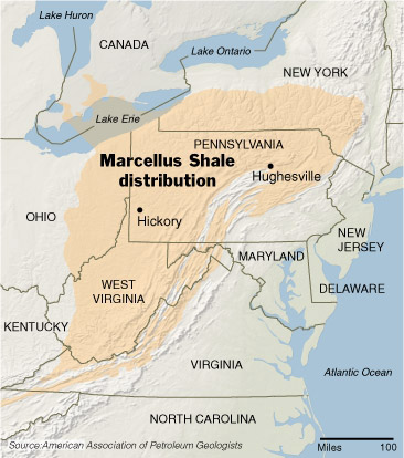
Second, geologists are telling the industry that there is evidence that very large deposits of gas are contained in a geological formation called the Marcellus Shale, which extends from Tennessee northward into central and northeastern Pennsylvania, including Wayne County, and the Southern Tier of New York State, including Sullivan County.
Third, new drilling techniques, principally developed by Halliburton, called horizontal drilling, can now recover gas deposits that were unrecoverable a short time ago.
No well permits have been given in Wayne County, but 14 wells have been created in Susquehanna County, according to the Pennsylvania Department of Environmental Protection (DEP). Also, no permits have been issued in Sullivan County, where the process of gas exploration got a later start.
Marcellus Shale
SUNY professor Gary Lash and his partner, Penn State professor Terry Engelder, are studying what they believe could increase national gas reserves by upward of 20 to 25 percent.
“It’s a unit called the Marcellus Black Shale, and we’ve been looking at the way it’s fractured as a means of extracting the natural gas from it,” Lash said. “The United States Geological Survey has predicted two trillion cubic feet of natural gas in this Marcellus deposit. Our estimates are perhaps as high as 500 trillion cubic feet.”
“The value of this science could increase the net worth of U.S. energy resources by a trillion dollars, plus or minus billions,” Engelder said.
Drilling techniques
While the estimated figures of available natural gas sounds great, the trouble has been the extraction process and the science behind it, Lash said.
The gas is trapped in microscopic spaces in rock formations, he said, and that’s where the horizontal drilling comes in. After drilling straight down to a certain depth, the drill is turned sideways in order to drill perpendicular to naturally occurring vertical fractures in the rock. “Then,” said Lash, “what they do is they pump fluids down into the well to pressurize the rocks, causing them to crack, and that allows the gas to migrate upward through a complex piping system that is installed after the drilling.”
A drill can be as deep as 7,000 feet. It takes about 660,000 to one million gallons of water for each well. The DEP issued 7,241 well permits throughout Pennsylvania in 2007, according to Ron Gilius of the DEP’s Oil and Gas Management Department.
With the drilling taking place horizontally, one question being asked by residents who do not sign leases is if the company gets gas from under their property, what happens to their rights? “Horizontal drilling under a property where the company does not possess a lease is a trespass,” said Stephen Rhoads, president of the Pennsylvania Oil and Gas Association. “It’s illegal for them to do that.”
A landowner who signs a lease will get a bonus, a rental fee and, if gas is discovered, will receive a royalty of about 12.5 percent of the value of the gas. Some landowners have been able to negotiate the royalty to 18 percent. Bonuses and rentals are usually $5 per acre per year for five years.
Moving the gas from the ground to the refineries
Any gas recovered from wells must be transported to major gas lines such as the Tennessee Pipeline in Pennsylvania or the Millennium Pipeline in New York to be sold to the public.
The agencies that regulate the smaller pipelines, which take the gas to the major ones, are the state public service commissions (PSC), not agencies like DEP or DEC, according to Rhoads. But the PSCs do not regulate a third class of pipelines, the gathering pipes.
“There are gathering pipelines that merely take the gas to a holding tank or to another line coming from a well,” Rhoads said. “These are handled by the regulating agency like the DEP and the DEC.”
Several meetings have been held
The Penn State Cooperative Extension has held several meetings in Wayne County that introduced land owners to the vagaries of lease-signing, warning them that they must consult an attorney before they sign, preferably an attorney conversant with gas and oil drilling.
A group of landowners in Wayne County have formed an organization called the Northern Wayne Property Owners Alliance, which represents about 10,000 acres of land mass. The group will act together in the signing of any leases, according to leaders of the group. The organization has as its goals property protection, sensitivity to the environment and community, a contract that can be severed that includes increased compensation and royalties for landowners.
PA state senator Lisa Baker and state assemblyman Michael Peifer organized a public meeting with the Pennsylvania Department of Environmental Protection (DEP) to explain the permit process and the inspections of drilling sites. About 250 people attended that meeting on Wednesday, February 20.
There has been at least one meeting organized by Cornell Cooperative Extension for New York property owners, which brought in experts from the New York State Department of Environmental Conservation (DEC), who also explained the permit and inspection process of gas drilling.
A group of citizens opposed to the drilling, called the Damascus Citizens for Self-Government and Friends, has held two meetings. The last meeting introduced a speaker, Ben Price, director of the Community Environmental Legal Defense Fund (CELDF), who explained how his organization guided several Pennsylvania townships, helping them to pass laws prohibiting corporations from coming into their communities to carry out projects to which the community objected.
Some of the dangers to the environment, according to their website, are water contamination, decreased property values, soil contamination, depletion of the water table, increased heavy traffic and occasional pipe-line explosions.
There's Gas in Those Hills
There’s Gas in Those Hills
HUGHESVILLE, Pa. — At first, Raymond Gregoire did not want to listen to the raspy voice on his answering machine offering him money for rights to drill on his land. They want to ruin my land, he thought. But he called back anyway a week later to hear more.
By the end of February, he had a contract in hand for $62,000, and he pulled together a group of 75 neighbors who signed $3 million in deals.
“It’s a modern-day gold rush in our own backyard,” Mr. Gregoire said.
 Not just his backyard either — a frenzy unlike any seen in decades is unfolding here in rural Pennsylvania, and it eventually could encompass a huge chunk of the East, stretching from upstate New York to eastern Ohio and as far south as West Virginia. Companies are risking big money on a bet that this area could produce billions of dollars worth of natural gas.
A layer of rock here called the Marcellus Shale has been known for more than a century to contain gas, but it was generally not seen as economical to extract. Now, improved recovery technology, sharply higher natural gas prices and strong drilling results in a similar shale formation in north Texas are changing the calculus. A result is that a part of the country where energy supplies were long thought to be largely tapped out is suddenly ripe for gas prospecting.
 Pennsylvania, where the Marcellus Shale appears to be thickest, is the heart of the action so far. Leasing agents from Texas and Oklahoma are knocking on doors, leaving voice mail messages and playing host at catered buffets to woo dairy farmers and retirees. They are rifling through stacks of dusty deeds in courthouse basements to see who has underground mineral rights to the deepest gas formations.
Thomas B. Murphy, a Pennsylvania State University educator who runs a program to instruct landowners on their rights, estimated that more than 20 oil and gas companies will invest $700 million this year developing the Marcellus Shale. Up to one half of that will be invested in Pennsylvania, he estimated.
 The cost to companies for leasing mineral rights jumped from $300 an acre in mid-February to $2,100 now. “It shows you the pace this is going,” Mr. Murphy said. “I would call it breakneck.”
Dale A. Tice, a lawyer representing landowners in lease negotiations, said companies were on a “feeding frenzy.”
Industry experts say in the last three years companies like Anadarko Petroleum, Chesapeake Energy and Cabot Oil and Gas have leased up to two million acres for drilling in the region, half of that in the last nine months.
Whether their bets will pay off is by no means a sure thing.
 Researchers at Penn State and the State University of New York at Fredonia estimate that the Marcellus has 50 trillion cubic feet of recoverable natural gas, roughly twice the amount of natural gas consumed in the United States last year. But government estimates of the amount of gas recoverable from the Marcellus are relatively modest.
Early test results have encouraged companies to keep drilling, but most are holding details of their test wells close to the vest.
The company that has done the most work is Range Resources of Fort Worth, which says it plans to invest at least $426 million in the Appalachia region this year.
The company has reported promising results from the first 12 wells that it has drilled horizontally, the technique considered by most experts to be the most effective in the Marcellus. The most recent six have each produced more than three million cubic feet of production a day in recent months, and company executives say that is better than the average for wells recovering natural gas in the Barnett Shale in north Texas.
“The Marcellus is important to Range and it could be important to the country but it really is still early,” said Rodney L. Waller, a senior vice president at Range. “I can build you a scenario where it can be significantly better than the Barnett but it’s a function of economics.”
Energy experts say the Marcellus, along with other smaller shale formations being developed around the country, is coming under scrutiny at an opportune moment, just when conventional domestic natural gas production and imports from Canada are diminishing. With easy-to-find gas fields in decline, the country will need to explore in deeper waters in the Gulf of Mexico and penetrate deeper under the surface on land.
If all goes well, the Marcellus could help moderate the steep climb in natural gas prices and reduce possible future dependence on natural gas from the Middle East, which is beginning to arrive at coastal terminals in liquefied form.
Natural gas in the Marcellus and other shale formations is sometimes found as deep as 9,000 feet below the ground, a geological and engineering challenge not to be underestimated. The shales are sedimentary rock deposits formed from the mud of shallow seas several hundred million years ago. Gas can be found trapped within shale deposits, although it is too early to know exactly how much gas will be retrievable.
The gas from all the shales combined “is a game changer,” said Robert W. Esser, an oil and gas expert at Cambridge Energy Research Associates. He estimated that shale produced four billion cubic feet of gas a day on average last year, or about 7 percent of national production, and that shale gas production would increase to nine billion cubic feet a day by 2012, or about 15 percent of expected national production.
The New York State Energy Research and Development Authority estimates that developing New York’s portion of the Marcellus could roughly double the amount of natural gas now produced in New York. Currently that is about 55 billion cubic feet a year, providing for 5 percent of the state’s needs.
The Marcellus has suddenly become attractive in large part because natural gas prices have spiked in the last several years and the geologically similar Barnett Shale has been an industry sensation.
By using horizontal drilling techniques, oil and gas companies have been able to draw natural gas from underneath the city of Fort Worth, even from below schools, churches and airports. The companies have perfected hydraulic fracturing techniques, pumping water and sand into well bores to fracture shale and release gas from its pores.
Production in the Barnett has exploded from a trickle five years ago to over three billion cubic feet a day, and energy experts say that number could more than double by 2015. Shale gas development in other parts of Texas, Louisiana and Arkansas has also shown promise.
But no formation compares in size to the Marcellus. It is deeply entrenched in wooded and mountainous countryside and expensive to reach. But the reserve is also within short pipeline distance from some of the nation’s most energy-hungry cities.
Still, not everyone here is happy about all the leasing and drilling. At meetings with the companies, landowners have asked questions about potential hazards to water and woodlands.
Keith Eckel, 61, a grain farmer with 700 acres in northeastern Pennsylvania, said he had not decided whether to let the companies drill on his property. “Farmers have taken care of this land all their lives and don’t want to see it destroyed,” he said.
But many farmers and retirees in rural Pennsylvania appear excited that their lives are about to change.
“Now I can retire,” said Robert Deiseroth, a 63-year-old farmer and auctioneer from the town of Hickory, who recently received a $16,000 royalty check from Range Resources that he hopes will be repeated month after month. “This was a godsend for me. If it weren’t for this I would have to sell off some of my land to get some money for retirement.”
Mr. Deiseroth has put new windows in his house, bought a new fishing boat and plans to build a new garage. His 89-year-old father and 90-year-old mother, who live nearby, just got a $20,000 monthly check. His father has replaced the golf cart he drove around his farm with a Kubota utility vehicle, while his mother has bought a flat-screen television.
“When Range came in a lot of people didn’t like it,” Mr. Deiseroth said, “But things changed when they started getting their checks.”
History of the Catskill Park and Forest Preserve
- Written by Norm Van Valkenbergh; compiled and edited from various sources by Chris Olney; with some additions by Chris Olney
original link is here:
http://www.catskillpark.org/history/forest.htm
The history behind the creation, purpose, and evolution of the Catskill Park and Forest Preserve is not fully understood by many. To learn the context of how the Catskill Park and Forest Preserve came to be, one has to look at what was going on in the Adirondacks and in the State Capitol during the 1700's and 1800's.
In the early years of New York State, and indeed the nation, the State was the owner of several million acres of forested land. Following the Revolutionary War, in 1779, the new State's fledgling legislature passed what was referred to as the 'Act of Attainder' law, officially transferring all lands owned by the Crown of England as of July 9, 1776 to the people of New York. The same act also voided the land titles of those who had remained loyal to the Crown during the fight for independence and declared those lands to be owned by the State. These lands amounted to approximately seven million acres and were mostly in the Adirondacks, covering that entire large region. In other parts of the State, huge tracts of land had been patented away by the Crown to individuals long before and were now mostly settled. This was especially true in the Catskills where Queen Anne had granted one and a half million acres to Johannes Hardenbergh and his partners on April 20, 1708. The State therefore inherited little or no land in the Catskills when the Act of Attainder was passed.
There was little or no preservation sentiment this early on, and settlement and industry were the primary motivating social forces of the times. The young state government had little revenue to keep it functioning this early on, and public officials seemed bent on getting rid of the millions of acres of land the State now held in the Adirondacks; a seemingly inexhaustible supply of natural resources. Early state legislatures, beginning in the 1780's and continuing for over 50 years, passed a series of laws designed for easy disposal of the "waste and unappropriated lands" of the Adirondacks. They sold off public land to private individuals for one shilling per acre, and exempted those lands from state taxes for a seven year period. The single largest of these land grants was made to Alexander Macomb in 1792, when the State sold 3,635,200 acres to Macomb for "a generous eight pence per acre." Most of the buyers, however, were logging and railroad companies who were interested in turning a quick profit from cutting and selling timber. By the early 1800's the lumbermen had exhausted most of the easily accessible tracts in the flatlands and began to move up into the greener areas of the surrounding mountains. The State succeeded in getting rid of its Adirondack land, conveying nearly all of it by about 1820. Private landowners also often succumbed to the pressures of the logging companies when they could no longer deal with the burden of property taxes. After the profitable trees and other resources were removed, the companies usually then got out and allowed the land to return to the State for unpaid property taxes. Much of that land returned to public ownership far depleted in value after the removal or other destruction of the forest resource.
While the logging industry was the worst offender in the despoliation of the forests, other enterprises were also to blame. The tanning industry, especially in the Catskills, wiped out hemlock trees to the extent that tanneries were forced to give up the business because of the lack of readily available hemlock bark. The paper industry seriously depleted the spruce, pine, basswood, popple, and white birch. The charcoal industry thrived on clear-cutting the area of its operation. The forested area of New York's mountains was also decreased by major fires caused by careless lumbermen. Timber thieves stripped the unprotected state-owned lands. And of course the forests were further encroached upon by the settlements and farms that expanded into the interior of both the Adirondacks and the Catskills in the early 1800's. Following a tour of the United States in 1831-32, French nobleman Alexis de Tocqueville wrote of his observations and impressions; "In Europe people talk a great deal of the wilds of America, but the Americans themselves never think about them; they are insensible to the wonders of inanimate nature. Their eyes are fired with another site; they march across these wilds, clearing swamps, turning the courses of rivers…" Later, in the 1850's, the state legislature gave the railroad companies the right to purchase many thousands of acres of the remaining State lands, leaving only the inaccessible mountain peaks and passes in the distance.
The fish and game of the mountains were treated with the same careless abandon as the forests themselves. Early journalists and authors, after visiting the Adirondacks and Catskills, wrote of the seemingly infinite supply of sport that could be had in those areas. Stories of catching 120 pounds of trout in two hours, of shooting five deer in one month, or of catching a 19-pound trout were not uncommon and were no doubt true, because there were no laws prohibiting such excessive harvests of fish and game. Tales such as these brought hunters and fishermen to the mountains in droves with the inevitable result that by 1820 the last trout was gone from Saratoga Lake; by 1822 the wolf had disappeared; the moose, elk, and panther disappeared; no more 19-pound trout were reported. Hotels and spas sprang up in what forests were left, serviced by extensive new railroads, and by 1850 America's first wilderness was no more.
But popular attitudes about nature slowly began to change in the early to mid-1800's, and a romantic movement began to idealize nature and provide a voice to counter our culture's steady consumption of natural resources and degradation of natural systems. Famed painter Thomas Cole began painting idyllic scenes in the Catskill Mountains and Hudson Valley in the 1820's, and in 1839 Charles Cromwell Ingham, founder of the National Academy of Design, first exhibited his oil painting of "the Great Adirondack Pass" inspired by a geology survey he participated in two years earlier. Such works began a tradition of Adirondack and Catskill landscape painting that would be popularized by the 'Hudson River School' of landscape painters who came after them.
Dr. Elliot Vesell, scholar of the Hudson River School, writes, "The work of the Hudson River School represents the first, and perhaps the last, systematic attempt to depict on canvas a unified vision of the American landscape. It celebrated the wonders of nature in this country by elaborately describing the facts of natural landscape and by presenting seemingly endless vistas through clear uncontaminated air." Vesell maintains that what the dozen or so artists of the Hudson River School shared was "a common spirit of devotion to nature and a common background of aesthetic ideas", and that their collective achievement in the mid-1800's was "to present a new view of nature and of man's relationship to nature which had widespread ramifications in American literature as well as in other aspects of American culture."
The paintings of the Hudson River School, along with the writings of authors and poets such as James Fennimore Cooper, Ralph Waldo Emerson, Henry David Thorough, and Walt Whitman, began to influence popular American conceptions about the value of nature. Vesell states that both the painters and writers of the early and mid-1800's generally "associated nature with virtue and civilization with degeneracy and evil", and summarizes that the basic message of popular nature writing of the time was that "Americans, particularly close to nature, were still virtuous, but with the march of civilization as measured by the progress of the axe through the forests, virtue would vanish, health would be destroyed, and the nation's personality lost." Author Peter Wild notes that Thoreau was one of the earliest advocates for setting aside wild lands and leaving them in their natural state, and as early as the 1830's artist George Catlin was advocating for a system of national parks. A growing urban population began to embrace the romanticism of nature and sought out beautiful places among the rivers and mountains to relax, recreate, and improve their physical and mental health.
The importance of forests in the matter of water supply began to be recognized in the 1850's. Water, of course, was necessary for drinking purposes, and for the lumbering industry and most other businesses of that time it was the least expensive and most convenient mode of transportation. Early naturalists and scientists pointed out that continued depletion of the woodlands of important watersheds seriously endangered the maintenance of stream flows and hastened flooding and erosion of valuable topsoil. Some early writers and editors in New York finally recognized that it was time for action and called for a new Adirondack policy. S.J. Hammond, in his 1857 book Wild Northern Scenes, said of the Adirondacks, "Had I my way I would mark out a circle of a hundred miles in diameter and throw around it the protecting aegis of the constitution. I would make it a forest forever." George Dawson of the Albany Evening Journal said much the same thing in editorials of the late 1850's, and in an 1864 editorial of the New York Times, Henry J. Raymond asked that concerned citizens get together and "seizing upon the choicest of the Adirondack Mountains, before they are despoiled of their forest, make of them grand parks owned in common ..."
It was also in 1864 that George Perkins Marsh published Man and Nature; or Physical Geography as Modified by Human Action. This work is essentially one of the first textbooks on ecology, and in it Marsh describes the relationship of one part of the environment to another, and how the influences of man impacts that relationship. Marsh singles out forestland in particular as critical for holding together other important components of a natural landscape. The book did not specifically address New York State, however it became a foundation and influencing factor for others arguing for the New York Forest Preserve in later years. People with scientific backgrounds gradually began to join the battle for forest protection in New York. Franklin B. Hough, a doctor and noted historian from Lewis County, who in 1881 became the first chief of the Federal Division of Forestry (forerunner to the U.S. Forest Service), traveled the backcountry of the Adirondacks directing the 1865 state census. He was appalled at the condition of the forests and was scientist enough to realize the disastrous results that could occur if denudation of the watersheds was allowed to continue. He began to preach the need for adoption of forest conservation practices, and he used his influence with friends in government to arouse public sentiment for his cause. Famed landscape architect and proponent of wild parks, Frederick Law Olmstead, also advocated the setting aside of land to protect the Adirondacks.
Conservationist John Muir and the Catskill's own nature essayist, John Burroughs, carried on the American popularization of nature in the latter half of the 19th century. Such authors, according to Peter Wild, "saw their souls reflected in America's wildlife and woodlands. To them, setting aside forests as unexploited wholes often took on a religious imperative. Their books and articles in magazines stirred the public to re-evaluate its long-ignored wild heritage." Similarly, sportsmen's groups and various hunting and fishing periodicals began the fight for a better system of game laws and game management in the 1860's and 70's. George Bird Grinnell, paleontologist, naturalist, and editor of the popular publication Forest and Stream, would later argue continually in the final decade of the century for sound forest management in the Adirondack Forest Preserve. Despite the formation of the Commission of Fisheries in 1868, the State's first natural resources-related commission, individuals eventually took matters into their own hands by buying large tracts of land and forming private fishing and hunting clubs. Trout fishing historians Austin Francis (in his book "Catskill Rivers") and Ed Van Put (in his book "The Beaverkill") tell the stories of several such fishing clubs here in the Catskills. Noted angling clubs such as the Willowemoc Club became established in 1868, the Salmo Fontinalis Club in 1873, the Beaverkill Association (later the Beaverkill Trout Club) in 1875, the Beaverkill Club in 1878, the Balsam Lake Club in 1883, the Fly Fishers Club of Brooklyn in 1895, and the Tuscarora Club in 1901.
The economic motives of powerful businessman of the time were almost as strong as the motives of conservationists for forest and watershed protection in New York's mountain areas. Peter Wild notes that business groups such as the Manufacturer's Aid Association of Watertown were big supporters of the creation of a New York forest preserve "because of industry's dependence on a steady supply of water power, which only healthy forests could provide", and that "business leaders in New York [City] recognized the link between the city's growth and nature. They fretted about sufficient drinking water but also about how to keep the Erie Canal full, their economic lifeline."
Verplanck Colvin, an Albany man trained in the law and a self-made land surveyor, first visited the Adirondacks in 1865 and "was amazed at the natural park-like beauty of this wilderness", and began suggesting the preservation of the remaining wilderness areas as a state park. On October 15, 1870, Colvin climbed Mt. Seward in the Adirondacks, and recorded that "the view hence was magnificent, yet differing from other of the loftier Adirondacks, in that no clearings were discernable; wilderness everywhere; lake on lake, river on river, mountain on mountain, numberless." It was at this place, and at this time that the Forest Preserve of New York State started on the path toward reality. Following his trip, Colvin said in the 24th Annual Report of the New York State Museum of Natural History that "… these forests should be preserved; and for posterity should be set aside, this Adirondack region, as a park for New York ..." No mention was made of the Catskills. The forest protection ideas of Colvin and Hough, who met each other at meetings of the Albany Institute (a respected literary and scientific society), were well received by people who saw the need for a more reliable and clean water supply for Albany, possibly from the Hudson River emanating from the Adirondack Mountains.
The State legislature was paying attention to Albany's recent drought and water supply problems, and out of it all came an 1872 law (Chapter 848) that established "A commission of State parks ... to inquire into the expediency of providing for vesting in the State the title to the timbered regions lying within the counties of Lewis, Essex, Clinton, Franklin, St. Lawrence, Herkimer and Hamilton, and converting the same into a public park." The Commissioners, in reporting their results to the 1873 Legislature, said "… we are of opinion that the protection of a great portion of that forest from wanton destruction is absolutely and immediately required."
The report outlined the scarcity of settlements in the area and pointed out the disastrous effects that mining, tanning, lumbering, and forest fires had had on what was once a vast tract of virgin forest. The report deplored the early sales of land to private individuals for nominal sums and the outright grants of huge tracts to railroad companies. It tabulated the public acreage in those Adirondack counties, as of the date of the report, to be 39,854 acres, and noted that this was only a small fraction of the land holdings that had been vested in the public at the conclusion of the Revolutionary War. The report elaborated that the State of New York contained some of the most remarkable watershed areas in eastern North America, with the St. Lawrence River on the north, the Great Lakes on the west, the Allegany River on the south, and the Hudson on the east. The report did not recommend that the Adirondack forests be preserved forevermore, but it did recommend that consideration should be given to the utilization of the forests as a product or crop. It expounded on the value of boating, camping, hunting, and fishing "to strengthen and revive the human frame … to afford that physical training which northern America stands sadly in need of." It further pointed out the health-giving values of having a wilderness area accessible to a large population. It is worth noting that in this first official study the concepts of preservation, management, and recreational development were largely treated as compatible and simultaneously attainable.
Unfortunately, not much came of that report and opinion. However in 1874 Assemblyman Thomas Alvord introduced a bill entitled "AN ACT to create and preserve a public forest, to be known as the Adirondack Park." The bill though did not have a Senate sponsor and progressed no further. In 1876, the State Legislature did pass a law (Chapter 297) prohibiting "the disposal of any part of the public lands on Lake George or the islands thereof." In 1882 Governor Alonzo Cornell, in his message to the legislature, condemned the State's policy of selling its wild lands. He suggested that the uses of the Adirondacks should be carefully restricted. Similarly, Governor Grover Cleveland said in his 1883 message to the State Legislature that the Adirondack forests should be preserved, and that the present state lands and all other lands "it may hereafter acquire" should be declared "to be park lands."
All of the pressure being brought about by public officials, individuals, and the public-at-large began to take effect in 1883. In that year the Legislature passed a law (Chapter 13 of the Laws of 1883) prohibiting the sale "of lands belonging to the State situated in the counties of Clinton, Essex, Franklin, Fulton, Hamilton, Herkimer, Lewis, Saratoga, St. Lawrence and Warren", these being the seven counties inquired into by the 1872 Commission, plus Warren County, which includes Lake George, and the two additional counties of Fulton and Saratoga. Another law passed that year (Chapter 470) also helped lay the groundwork for the future Forest Preserve, by granting the Comptroller the authority to spend up to $10,000 to purchase forest lands with unpaid taxes in the Adirondacks - the first such appropriation. The foundation for the Forest Preserve was being laid, but the Catskills were not going to be a part of it. Or so it seemed.
With the enactment of the laws stopping the sales of Adirondack lands, it appeared that the State was going to continue to be a major landowner. Furthermore, additional lands were coming to the State for unpaid taxes and through partition sales. The time had finally come to provide some sort of management and protection to its ownerships. Accordingly, the deficiency budget of 1884 appropriated $10,000 to the Comptroller for "… perfecting the state's title to such lands; of definitely locating, appraising and examining them as may be required; of protecting them from trespassers or despoilers and prosecuting all such offenders, and generally of guarding, preserving the value of and protecting such lands …" The same budget (Chapter 551 of the Laws of 1884) provided $5,000 to the Comptroller "for the employment of such experts as he may deem necessary to investigate and report a system of forest preservation ..." Here now the Catskills had a chance at protection because these 'experts' were not confined to any single geographic area or list of specific counties.
The 'experts', or Commissioners as they called themselves, were led by Professor Charles Sprague Sargent of Harvard University, the country's premier dendrologist at that time. The Commission reported to Comptroller Alfred C. Chapin on January 23, 1885, saying that they had "devoted themselves industriously to the study of the question." They had visited the Adirondacks a number of times, had "caused a detailed examination of the position and condition of the Adirondack forests to be made by trained forest experts", and were convinced that something certainly did need to be done to preserve the forests. They noted the continued plundering in the Adirondacks that "reduces this whole region to an unproductive and dangerous desert." The Commission noted the advantages of a continuing forest on the flow of water and outlined the forest as a natural recreational area to be enjoyed by the people. It laid the blame for the destruction of the forests to the charcoal and lumber industries, the construction of numerous small reservoirs throughout the mountains, and forest fires. It pointed the finger of accusation at the railroads and loggers for the vast number of fires that were helping to destroy the remaining trees.
The Commission 'experts' had also "visited the forest region of Ulster and Delaware counties," but were not much impressed. They said, "The forests of the Catskill region are not unlike in actual condition those covering the hills which mark the southern limits of the Adirondack plateau. The merchantable timber and the hemlock bark were long ago cut, and fires have more than once swept over the entire region, destroying the reproductive powers of the forest as originally composed and ruining the fertility of the thin soil, covering the hills. The valleys have now, however, all been cleared for farms, and forest fires consequently occur less frequently than formerly. A stunted and scrubby growth of trees is gradually repossessing the hills, which, if strictly protected, may sooner or later develop into a comparatively valuable forest. The protection of these forests is, however, of less general importance than the preservation of the Adirondack forests. The possibility of their yielding merchantable timber again in any considerable quantities is at best remote; and they guard no streams of more than local influence. Their real value consists in increasing the beauties of summer resorts, which are of great importance to the people of the State."
The Commissioner's report recommended that the State not enter into the acquisition of additional lands by condemnation, but rather to initiate an acquisition program based on purchases, which would be better received by the public. It stated however, that there would be no benefit to purchasing additional lands if past poor management practices were to continue. The commissioners recommended that a forest commission be set up to create regulations and policy for the administration of the public lands. The report went on to recommend legislation establishing a Forest Preserve of "all the lands now owned or which may hereafter be acquired by the State of New York" to the ten Adirondack counties listed in the 1883 law and the additional county of Washington, with such lands to "be forever kept as wild forest lands." A second law was recommended to amend the penal code to set forth punishments for violations relating to forest destruction, and a third law was recommended to provide that the lands of the Forest Preserve would be taxable for all purposes.
The Comptroller was willing to accept and endorse all of this, and submit the recommendations to the state legislature for action. So the Catskills were not intended to be included in the new Forest Preserve after all. Comptroller Chapin, however, had not fully reckoned with the likes of Cornelius Hardenbergh. The fact that the State land "now owned or which may hereafter be acquired" in the Catskills did become part of New York's Forest Preserve, and subsequently that a Catskill Park was created, all had to do with the tenacity of Hardenbergh and a complicated series of laws dealing with property taxes (and the non-payment of them).
Cornelius A.J. Hardenbergh [see figure] was a bachelor, farmer, merchant, and public servant - not necessarily in that order. He owned and operated a 110-acre farm on the northerly bank of the Shawangunk Kill at the point where the stream formed the southerly boundary of the Town Shawangunk and the line between Ulster and Orange Counties. He picked up his mail in Pine Bush, just across the kill in Orange County, but he resided in Ulster County. Hardenbergh was an avowed opponent of taxes. When a tax was to be imposed on his wheel-making shop and business in the early days of the Civil War, he closed his shop rather than pay the tax. An admiring public elected him supervisor of the Town of Shawangunk, and then served on the Board of Supervisors of Ulster County, sometimes as its chairman. It was in this capacity that Hardenbergh became involved in a running battle with State Comptroller Chapin and his predecessors over state taxes being assessed against the lands acquired by the county at tax sale. No matter that Ulster County was not being treated any differently from any other county in the state, Hardenbergh opposed such taxation by the State.
In the 1870's, a succession of laws were passed requiring county treasurers to collect all taxes levied on lands for state or county purposes. These laws further required the counties to pay the state taxes by the first of May each year whether the treasurers had been able to collect them or not. Ulster County was added to the list of counties subject to these requirements by Chapter 200 of the Laws of 1879. If that wasn't bad enough, Chapter 371 of the Laws of 1879 was passed a month later to restate, word for word, the same provisions as were in Chapter 200, allegedly enacted to correct a minor error in the title of the first law. If Hardenbergh wasn't incensed the first time around, he surely was at the passage of the second law. Then came Chapter 382 of the Laws of 1879, which provided that the Comptroller would issue a deed to the counties for each parcel of land not redeemed or sold at the 1877 tax sale. That law further required that the counties were liable for the current unpaid taxes on these lands, as well as for later taxes that would come due. If the counties didn't pay the taxes in ninety days, then interest at the rate of 6% would be added.
The Comptroller at this point was holding the winning hand. Hardenbergh, however, saw to it that Ulster County did not pay the Comptroller's bills. He won a minor point when he influenced the passage of Chapter 573 of the Laws of 1880. This law restated the procedures for publishing notices of pending tax sales as such procedures had been set out in the 1879 laws. There was one change. The earlier laws had said, "the publishing of the said notice not to exceed the sum of two dollars for each newspaper so publishing each of the several notices..." The 1880 law contained the same wording but added, "excepting in the county of Ulster, wherein the sum shall not exceed one dollar."
The next round also went to Hardenbergh. The last 1879 law had provided that after the state acquired title to unredeemed and unsold lands, the Comptroller would deed these lands to the respective counties. Chapter 260 of Laws of 1881 changed that for Ulster County only. This law said that, "should there be no purchaser willing to bid the amount due on the lot or parcel of land to be sold," then the Ulster Country treasurer could bid on the "lot or parcel of land for the county." He then, and not the Comptroller, would issue the deed to the county or, if so directed by the Ulster County Board of Supervisors, he could sell the land. Other provisions of this law clearly set out the battle lines. One section stated, in referring to the earlier laws, "Where any authority is given or duly enjoined by those laws on the comptroller of the state, the same authority shall be exercised and the same duty shall be devolved on the county treasurer of Ulster County." One of the final sections of the law provided that lands acquired by Ulster County for unpaid taxes "shall be exempt while so owned by said county from all taxes" and directed the treasurer "to strike such land from the tax roll ..." Finally, it repealed, "All acts or parts of acts inconsistent herewith, so far as the county of Ulster is affected ..."
The Comptroller won the round after that. Chapter 402 of the Laws of 1881 was passed just two weeks after Chapter 260. It repeated many of the provisions of the 1855 law, on which all of the later laws had been based. While not ever mentioning Ulster County, the language of the law makes it clear to what county it was directed. The listing of counties required to turn over delinquent tax lands to the Comptroller for sale, which did not include Ulster County, was followed by the phrase, "or any other county for which there may, at the time, be a special law authorizing and directing the treasurer thereof to sell 'lands of non-residents' for unpaid taxes thereon ..." That, of course, meant Ulster County. This latest law put things back the way they were. The Comptroller was directed to issue deeds to the counties for unredeemed and unsold lands. The final provision of the law stated, "All acts and parts of acts inconsistent with the provisions of this act are hereby repealed."
The Comptroller was still ahead with the passage of Chapter 516 of the Laws of 1883. This law set out what was to happen to the lands not sold on the 1881 tax sale. It included Ulster County again not by name, but by the "all other counties" phrase. Again, the Comptroller was to issue the deeds to the counties and the counties would be liable for taxes due and 6% interest if the Comptroller's bills were not paid. In the case of Ulster County, they weren't. By this time, in fact, the county was in arrears some $40,000. From his vantage point on the fringe of Ulster County, Hardenbergh needed someone "in high places." In 1879, the year when Ulster County began to run up its tax bill under the provisions of the laws detrimental to its interest, one of those representing the county was a freshman Assemblyman, George H. Sharpe from the City of Kingston. In that year all three Assemblymen from Ulster County were freshmen, still novices at the devious routes of lawmaking. In 1880, when it appeared that Ulster County was on the verge of getting the upper hand, Sharpe had become Speaker of the Assembly. It was he who had successfully moved Chapter 260, Ulster County's high point in the battle, through the legislative process. He was unable, however, to forestall the passage of Chapter 402. In 1882, a quiet year for Ulster County and its tax problems, Sharpe was serving his last year as an Assemblyman and was no longer Speaker. He had, however, provided good service to his Ulster County constituency.
Another freshman Assemblyman took his seat in 1882. Alfred C. Chapin, representing Kings County, would later become the last mayor of the independent City of Brooklyn and would preside over its amalgamation into the City of New York at the turn of the century. Speaker of the Assembly when Chapter 516 was enacted in 1883, he became Comptroller the following year. It was he who would do the final battle with Hardenbergh, who was elected Assemblyman at the November 1884 general election. Now Hardenbergh would carry his own bills, and he wasn't long in making himself known. Early in the session, influenced by the 1883 law prohibiting the sale of state lands in the eleven Adirondack counties, he introduced a bill to prohibit the state from selling its land in Ulster County also. It didn't get anywhere. Undeterred, he and his Ulster County colleague, Assemblyman Gilbert D. B. Hasbrouck of Port Ewen, went to work on a bill that was enacted on April 20, 1885 - about the same time that Comptroller Chapin was receiving the report of the 'experts' investigating "a system of forest preservation."
Chapter 158 was a sweeping piece of legislation. It repeated, by listing every one of the 1879, 1880, 1881 and 1883 laws "as the same in any wise relate to the county of Ulster" and relieved the county "from the operation of said laws." It directed the Comptroller to cancel all previous sales of lands to Ulster County under any of the repealed laws and to convey those lands to the state. Finally, and most importantly, it directed the Comptroller to give credit on his books to Ulster County for the principal and interest due on the lands that would be conveyed to the state. In one law, Ulster County was out from under its debt and its large tax sale land holdings were owned by the state.
Comptroller Chapin was supportive of the recommendation to create a forever wild Forest Preserve of the state lands in the eleven Adirondack counties. He even felt it only fair, as recommended by the report, that the state should pay taxes on these lands to the local governments where they were located. Hardenbergh had a particular ally in the Senate who also supported the creation of the Forest Preserve. Senator Henry R. Low, representing Orange County, was a near neighbor of Hardenbergh's, residing at Middletown, only fifteen miles south of Pine Push, on the banks of the Shawangunk Kill. Low had been a sponsor of the original bill recommended by the 'experts' and was a major participant in the conferences in which the final bill was written. He introduced the final bill in the Senate. The sponsor in the Assembly was James W. Husted from Peekskill in Westchester County, just across the Hudson River from Orange County.
And so it was that the New York State Forest Preserve was created on May 15, 1885, when Governor David B. Hill signed Chapter 283 of the Laws of 1885. This law established a three-person Forest Commission "appointed by the governor by and with the advice and consent of the senate" to have "care, custody, control and superintendence of the forest preserve." The Commission was empowered to "employ a forest warden, forest inspectors, a clerk and all such agents, as they may deem necessary ..." It stated (in Section 8) that, "The lands now or hereafter constituting the forest preserve shall be forever kept as wild forest lands. They shall not be sold, nor shall they be leased or taken by any person or corporation, public or private." As had been recommended by the 'experts', this law defined the Forest Preserve as being, "All the lands now owned or which may hereafter be acquired by the state of New York, within ..." the eleven Adirondack counties except such lands in the Clinton County towns of Altona and Dannemora, in order to provide for the prison at Dannemora and the lands used by the prison for its wood supply. Tacked onto the end of the list of Adirondack counties, thanks to the political maneuvering of Cornelius Hardenbergh, were the three Catskill counties of Greene, Ulster and Sullivan. The Forest Preserve began with 681,374 acres in the Adirondacks, and 33,894 acres in the Catskills.
Hardenbergh was serving the second year of his term when Chapter 280 of the Laws of 1886 was enacted. This was the companion bill recommended by the 'experts' to provide for taxation of the state lands. It stated that all lands of the Forest Preserve "shall be assessed and taxed at a like valuation and at a like rate as those at which similar lands of individuals within such counties are assessed and taxed ..." It set out the procedures by which and the dates when the Comptroller was required to certify and the State Treasurer was required to pay annual taxes to the treasurers of the Forest Preserve counties. Thus, not only was Ulster County free from its tax bill, but from that time forward it has received taxes from the state on those same lands that had been involved in the battle.
Hardenbergh left the Assembly at the end of his two-year term and went back to Ulster County. Over the years, many have debated just who was the "father" of the Adirondack Forest Preserve. The favorite seems to be Verplanck Colvin, and rightly so. However, no such debate has asked who was the "father" of the Catskill Forest Preserve, probably because the Catskill Forest Preserve has just quietly existed without much controversy, and has therefore received less attention than its Adirondack counterpart. Those who know of Hardenbergh's involvement have debated his motives. Some say he was interested only in solving Ulster County's tax problems and took the way out offered by the times. Others say bringing the state lands of the Catskills into the Forest Preserve was his main goal and, in reaching that, he solved the tax problems. We probably will never know the answer, but the fact remains, whatever the motive, without Cornelius A. J. Hardenbergh, the people of New York State would not enjoy the benefits of a Catskill Forest Preserve. That is certainly reason enough to remember his place in history.
It took a few months to appoint the three-member Forest Commission. The first appointment was quickly made a week or so after the signing of the law - Theodore B. Basselin, a lumberman from Croghan in Lewis County with one of the largest timber cutting operations in the Adirondacks. It was not until September that the remaining two members were appointed; Townsend Cox, a New York City stockbroker from Glen Cove, Long Island and Sherman W. Knevals, a lawyer from New York City. They held their first meeting on September 23, 1885 and "took immediate steps to familiarize themselves with the duties and various interests intrusted [sic] to their charge." The preservation of forests was their principle objective, for the stated purposes of ensuring "the value of present and future timber; the value of forests as 'health resorts'; the conservation of sources of water supply; the increase of rainfall; and the climatic and sanitary influence of forests." They visited the Adirondack and Catskill regions. These visits were cursory only and they did not venture far from the main roads and villages. Instead, they hired "experienced, competent men … as special agents, who penetrated to every part of the wilderness."
In the case of the Catskills, the Commission did not really know what they had. After all, this addition to the Forest Preserve had been a last-minute political maneuver, and very little data existed as to the location of this state land asset. The Commission recognized in its first annual report that "the existence of the Catskill Preserve seems to be little known, although the State owns a large tract in the Catskill region." A tabulation of the state ownership did exist however, which indicated a total of 33,894 acres in the three Catskill counties. Greene County had 661 acres (507 acres in the Town of Lexington and 154 acres in the Town of Cairo). Sullivan County contained 502 acres (scattered in the Towns of Highland, Lumberland and Neversink). The remaining 32,731 acres was in Ulster County (with most of that being in the mountain Towns of Denning, Hardenbergh and Shandaken, principally on and around Slide Mountain). Most of this Catskill acreage was acquired by the State in the 1870's and 1880's as a result of tax sales and mortgage foreclosures. The Commission was quick to realize that the listing of Catskill counties was one short when they said, "The Catskill region occupies parts of four counties" and recommended a bill to add Delaware County.
The special agents who "penetrated to every part of the wilderness" came back with a different story than the 'experts' who had reported to Comptroller Chapin. The Catskill Forest Preserve, they said, "… is surrounded by the grandest of its scenery. Here the Slide Mountain rears its majestic form, surrounded by its retinue of lesser peaks. Here, also, are the deep, cool valleys, whose silence is broken only by the rushing cascades, or by the murmur of woodland sounds. Here are the rocky glens, among which the Peekamoose is so justly celebrated, while on every side the eye is greeted by an array of scenery unsurpassed throughout the State."
The streams also were "of more than local influence." The waters of the Schoharie Creek, they said, are "utilized as a feeder to the Erie Canal. ... The Esopus Creek ... pours its waters into the Hudson at Saugerties, affording an important water power, which is used to advantage by the manufacturers near its mouth. The east and west branches of the Neversink and the east branch of the Delaware all rise here, and flowing southward unite at Port Jervis and enter the Atlantic through Delaware Bay. ... Numerous mountain streams have become repopulated with trout, and now afford some of the best fishing in the State."
Even with that report, however, more needed to be known. In June of 1886, Commissioner Townsend Cox "penetrated" the interior of the Catskills himself when he climbed Slide Mountain, tallest peak in the Catskills. While Cox's trip was largely for political reasons, he did, in a meeting with reporters the following morning, stress the benefits of the Catskill Forest Preserve in maintaining the streams flowing from the area to form the rivers that were important to New York and its neighboring states.
In addition, the Commission "detailed Inspector Charles F. Carpenter to make a thorough examination of the Catskill Preserve." Carpenter stood fourth in line in the hierarchy of the staff employed by the Commission in 1886. Abner L. Train of Albany was secretary, Samuel F. Garmon of Lowville (Lewis County) was warden, William F. Fox of Albany was assistant warden, and Carpenter was the chief of two inspectors, drawing a salary of $125 a month. In addition, fifteen foresters were employed at $40 a month. All were headquartered throughout the Adirondacks except for one, Michael Hogan, who was stationed at Ellenville in Ulster County. Carpenter indeed made a "thorough examination" of the Catskill Mountains. His report covered 51 pages of the Commission's annual report for 1886. He first described the geography of the Catskills, their mountains, streams, lakes, ponds and soils. Then he detailed the forest cover of the area, deploring "the reckless waste going on all the time, and the noble forests mowed down to satisfy the cupidity of man …" He talked about the state lands composing the new Forest Preserve, and he too thought Delaware County should be added because "the State lands within that county are still under the control and management of the Commissioners of the Land Office and the State Comptroller. While this state of affairs exists the people of this county lose the benefit of the act ... which provides for the taxation of State forest lands in the counties embracing the forest preserve." After all, he said, "the State paid a tax of $638.25 for the year 1886" to Ulster County.
Carpenter knew of the fight waged by Ulster County over its taxes because he discussed the various laws that had been involved up to and including the act "passed April 20, 1885, just twenty-five days before the passage of the act creating the Forest Commission." All of it was, he said, "Through the enterprise of one or two citizens of Kingston an evidence of forethought and prudence, which from the earliest history of this region has always been justly attributed to the inhabitants of Wildwyk, now the city of Kingston."
Carpenter discussed the roads and highways and railroads that serviced the Catskills. He talked about the fine fishing and small-game hunting opportunities. He traced the history of the lumbering and tanning industries that had depleted the forests. He then described the "various industries" he had found "in making a tour of the counties embracing the Catskill forest preserve" town by town, village by village. He had, in fact, gone beyond the three counties, describing some industries in Delaware and Orange Counties as well. He was impressed by the Catskills, concluding that he had "rarely found ... an abandoned homestead ... This distinguishes this wild region from the similar one in the Adirondacks, where deserted homesteads are met at frequent intervals, and in places the dilapidated remains of whole villages ... The Catskill region as a whole has a good soil and friendly climate, which the Adirondacks can scarcely be said to possess."
After all that, one would have thought that the Catskills would have received some major attention from the Forest Commission. But it didn't. The Catskills slipped into the role of being secondary to the Adirondacks; a role that continues to this day. That may not be all bad, as any new idea is generally tried first in the Adirondacks and if it works, then it is applied to the Catskills, hopefully with all the quirks worked out. One beneficial result from the initial attention paid to the Catskills however, was the passage of Chapter 520 of the Laws of 1888, which added Delaware County to the county listing and made its 17,340 acres of state land a part of the Catskill Forest Preserve. Most of this land was south of the East Branch of the Delaware River and along the Ulster County line in the Towns of Andes, Colchester and Middletown. Also at this time was the first real attack on, and weakening of, the newly created Forest Preserve. Chapter 475 of the Laws of 1887 redefined a part of the duties of the Forest Commission and authorized the Commission to sell and convey "separate small parcels or tracts wholly detached from the main portions of the Forest Preserve and bounded on every side by lands not owned by the State, to sell the timber thereon, and to exchange these tracts for other lands adjoining the main tracts of the Forest Preserve." While this piece of legislation seems fairly definitive, it should be noted that no attempt was made to define the size of a "separate small parcel or tract." This law was presumably sponsored by the lumber interests, and it opened a crack in the door that had been slammed shut two years before. To some, it was not a good law; to others it was made to order. Significantly, it became a statute without the Governor's signature - he neither approved nor vetoed it in ten days and therefore it returned to the Legislature as law.
An Adirondack Park had been a concept talked about since the very first pleas were heard to do something about saving and preserving the Adirondack forests and mountains. An 1864 New York Times editorial by Henry J. Raymond had said, make "grand parks" of the "choicest of the Adirondack Mountains." Verplanck Colvin said, in speaking of the destruction of Adirondack forests in his 1870 report to the New York State Museum of Natural History, "The remedy for this is the creation of an Adirondack Park or timber preserve..." The 1872 Commission of State Parks was to look into converting the timbered regions of certain of the Adirondack counties "into a public park." Colvin, in his 1874 report to the Legislature on his "survey of the Adirondack wilderness," talked about the state acquiring all of the land in the High Peaks region of Essex, Franklin, and Hamilton counties and setting it aside as a park. He continued to be the chief proponent of the Adirondack Park idea during the 1870's and 1880's.
Throughout these times, those speaking of an Adirondack Park envisioned that all lands within the park boundary would be state-owned public land. By 1890, however, that concept was beginning to change. Governor David B. Hill, in his message to the Legislature of that year, thought a park should be outlined to include the "wilder portion of this (Adirondack) region covering the mountains and lakes" and, then acquire lands in that park area. Chapter 8 of the Laws of 1890 redefined the Forest Preserve by re-listing all of the counties that had been set forth the previous year (which had grown from the original listing to include Oneida County in the southwestern Adirondacks), but then it excepted form the Preserve all state lands within the limits of any incorporated village or city. Chapter 37 of the same year appropriated $25,000 to purchase lands in the Forest Preserve counties, which was the first such appropriation for the acquisition of lands to expand the Preserve. This same law also made reference to a State park as it might relate to the Forest Preserve lands.
The Forest Commission report for 1890 called attention to the existing scattered pattern of state land ownership and recognized that additions to this state land must come from purchases. It noted the public sentiment favoring acquisition and called for legislation to enable the state to acquire and hold state land in "one grand, unbroken domain." It stated that an advantage of increased ownership would be that greater control could be exercised against the railroads and trespass. The Commissioners revised their reasons for preserving forests to be for the "maintenance of timber supply; conservation and protection of watersheds; preservation and protection of fish and game; and the founding of a permanent public resort."
Notably, the 1890 Forest Commission Report included discussion on the subject of a proposed Adirondack Park. One of the most interesting parts of the report was the inclusion of a map of the Adirondacks on which a proposed park boundary had been delineated in blue. From that time forward, the phrases "inside the blue line" and "outside the blue line" have been used to describe lands inside and outside the Adirondack and Catskill Park boundaries. Unfortunately, the narrative of the report in regard to public ownership within a new Adirondack Park was contradictory. The commission seemed unwilling to say whether all lands inside the proposed park should be acquired by the State or not, so in different places in the text they said both. The report noted that it was unwise to proceed with acquisition of the entire Adirondack plateau, recognized the presence of villages and private clubs within the 'blue line', and concluded that proper forest management on private lands could be a compatible land use in the Park. But at the same time it said that all of the lands within the park boundary should gradually be acquired. There was also unclear language in regard to timbering on State lands inside and outside of the park boundary. The Commission felt that state lands outside of the park should be sold whenever those lands did not, in the opinion of the Commission, promote the purpose of the Forest Preserve, and the proceeds would then be used to buy additional lands inside the park. The Commission concluded by unanimously recommending the necessary legislation to establish and manage a park in the Adirondack wilderness, and state acquisition of title to all the forest lands within the limits of the park "which it is possible to acquire, in the shortest practicable time." Use of the word 'manage' would seem to leave the door open for the practice of forestry and lumbering on the State lands, and the use of the word 'forest' as an adjective modifying the word 'lands' suggests that it was the Commission's recommendation not to acquire non-forested lands within the 'blue line'.
The 1891 report of the Forest Commission again addressed the idea of an Adirondack Park, and this time recommended a bill to create the park. Again the Commission advocated for lumbering on Forest Preserve lands and for the sale of certain State lands outside the park. The report also referred to the sales of "separate small parcels and tracts" of land taking place under Chapter 475 of the Laws of 1887; with one of the tracts sold in the Adirondacks being a not-so-small 3,673 acres. As far as the Catskills were concerned, the most important part of the report was a recommendation to provide $50,000 to acquire "forest land situated within the counties of Greene, Ulster, Delaware and Sullivan, at a price not exceeding one dollar and fifty cents per acre …" The inclusion of funding for the Catskills, said the Commission, was because the 1885 law "establishing the Forest Preserve, contemplated a reservation in the Catskills .... and not without good reason." This good reason was that state ownership was necessary to protect "the watersheds of our great rivers" and because "the wooded slopes of the Hudson watershed demand special consideration." In making the first written reference to a Catskill Park, the Commission said, "But there are other important reasons for the establishment of a forest park in the Catskills." These other important reasons were that the Catskill Forest Preserve "is in close proximity to the great cities of New York and Brooklyn and many cities along the Hudson. It is easily accessible to three-fourths of the population of the State ... It is a favorite spot with the vast population of New York and Brooklyn on account of its accessibility, cheap railroad fare, and desirable accommodations for people of moderate means."
Chapter 707 of the Laws of 1892 created the Adirondack Park and defined it to be, "All land now owned, or which may hereafter be acquired by the state within" certain listed towns in the counties of Hamilton, Essex, Franklin, Herkimer, St. Lawrence and Warren, and stated that the state lands within the park were to "be forever reserved … for the free use of all the people." Private land was not included in this first definition of the Adirondack Park, and the boundary was primarily for the purpose of specifying an area of the Adirondacks where state land acquisitions should be concentrated. The law repeated most of the provisions of the bill recommended a year earlier by the Forest Commission, including the authority to sell Forest Preserve lands throughout the Adirondacks (but not the Catskills), and also lease lands for private camps and cottages. Governor Roswell Flower, in fact, thought that the State's judicious sale of timber and leases should pay for the maintenance of the Preserve. The new law did repeal Chapter 475 of the Laws of 1887, allowing land exchanges. The law unfortunately did not include the previously recommended funding or authorization for acquiring Forest Preserve lands in the Catskills.
A minor consolation to the Catskills was Chapter 356 of the Laws of 1892, which provided $250 to the Forest Commission "for completing the public path leading to the summit of Slide mountain, Ulster County, included within the preserve …" Townsend Cox, still one of the commissioners, must have hoped the funding would put the "public path" in better shape than when he had traveled it back in 1886. An 1893 budget bill (Chapter 726) provided $1,000, "For the expenses of examination of title and survey of lands owned by the state on Slide Mountain in Ulster County and other parts of the Catskills ..." The $250 "public path" money may not seem of much importance, but it was the first legislation to authorize a recreational trail and is the point of beginning of the present and extensive trail system throughout the Adirondacks and Catskills. The Catskills had a first after all!
The 1893 Forest Commission recognized that the $50,000 recommended for the Catskills in 1892 hadn't survived the legislative process. They didn't believe it proper to continue to discuss "the Adirondack wilderness to the utter exclusion of the interests of the Catskills." They thought some effort should be made to make "a solid tract of … these holdings ... in scattered lots ... by the purchase of additional lands, in order that they can be brought under some systematic management. ... We believe that it would be well to acquire 100,000 acres in the immediate vicinity of the lands mentioned." Accordingly, the Commission recommended a bill to purchase "sixty thousand acres" in the Catskills "at a price not exceeding one dollar and fifty cents per acre ..." As noted, this recommendation did not succeed either.
The Forest Commission and the State Legislature proposed and enacted laws in 1892 and 1893 that liberalized, weakened, and capitalized on the Forest Preserve, allowing the leasing, timbering, and building of new roads on state lands. These facts did not escape the general public, and the citizens of the State lost all faith in the Legislature and the Forest Commission and became incensed over the increased mismanagement of the State's wilderness areas - surely the time was right for a new program to be established. Governor Flower was also disappointed with the current state of Forest Preserve affairs, unhappy with both law and administration. He did not agree that public lands should be sold, and advocated for a well-planned and well-funded acquisition program. He called for state controls on private lumbering, and he asked that administrators of the Forest Preserve be "active, capable and honest men."
The public reached the limit of its patience, and in response to the repeated abuses in the management of the Adirondack Forest Preserve (such abuses were less common in the Catskills), mostly authorized by existing laws, a contingent of private individuals and organizations sought to assure the perpetuation of the Forest Preserve by giving it constitutional protection. They planned to address the issue in the State's Constitutional Convention of 1894. In the early days of the Convention no mention was made of forest preservation and no committee was appointed to study the issue, however behind the scenes some independent groups were at work on the issue. The New York Board of Trade and Transportation and the Brooklyn Constitution Club had opposed the Forest Preserve laws of 1893, but were unsuccessful in keeping that legislation from being passed. The groups then resolved to ensure meaningful preservation of the Adirondacks through the State Constitution, and had the issue presented in Albany. They outlined to the Convention the various abuses that had been allowed to continue within the Preserve, all of which were legal but certainly not in accordance with the wishes of the citizens of the State. They publicly announced that it was their intention to protect the Forest Preserve by having this protection made part of the constitution rather than leaving it in the hands of changing legislatures and inept forest commissions. A special five-member Committee on State Forest Preservation, chaired by New York City attorney David McClure, was established to recommend action to protect the northern woods.
Mr. McClure and other contemporaries such as Lewis County delegate Charles Mereness and Syracuse delegate William Goodelle urged the State legislature to think of the protection of New York's forestland as an inexpensive and sound investment. They pointed to millions of dollars being allocated by the wealthy state for things such as improvement and expansion of the State Capitol buildings, maintenance of waterways, and even World's Fair exhibits, but very little for forest preservation and the employment of wardens and foresters. They urged timely action to purchase and protect as much forestland as possible in the Adirondacks and Catskills. In his address to the Constitutional Convention, Mr. McClure stated that, "First of all we should not permit the sale of one acre of land. We should keep all we have. We should not exchange our lands - in an exchange the State is in danger of obtaining the worst of the taxing - and there is no necessity why we should part with any of our lands. We should not sell a tree or a branch of one. Some people may think in the wisdom of their scientific investigations that you can make the forests better by thinning out and selling to lumbermen some of the trees regardless of the devastation, the burnings and stealing that follow in the lumberman's track. But I say to you, gentlemen, no man has yet found it possible to improve on the ways of nature. In the primeval forest when the tree falls it is practically dead and where it falls it is a protection to the other trees; it takes in the moisture through its bark and rottenness and diffuses it down and into the soil … If our action here is practically unanimous, as I believe it will be, it will probably be followed by action on the part of the Legislature looking to the purchase of more forest lands. We can buy those lands for a trifle … Finally, the Legislature should purchase all of the forest lands, both in the Adirondacks and Catskills, not now owned by the State, and should preserve them, even though it costs millions of dollars to do it. The millions so invested will be well spent."
On September 15, 1894 the voting members of the constitutional convention passed the proposal for Forest Preserve protection under the constitution by a unanimous vote of 112-0. The Forest Preserve protection language was grouped with other changes suggested for the constitution, and in November the voters of the State passed the entire new constitution by a vote of 410,697 to 327,402 in the 1894 general election. A new article VII addressing the Forest Preserve was inserted into the revised and adopted Constitution, and included the wording, "The lands of the State, now owned or hereafter acquired, constituting the forest preserve as now fixed by law, shall be forever kept as wild forest lands. They shall not be leased, sold or exchanged, or be taken by any corporation, public or private, nor shall the timber thereon be sold, removed or destroyed." These two sentences completely did away with every abuse that had heretofore been legally perpetrated on the Forest Preserve. The exchange of lands was done away with; the sale of state lands was stopped; the leasing of small camp lots was discontinued; no more railroad grants would be made; and the timber on the state holdings would remain forevermore. The new state constitution went into effect on January 1, 1895. From this day forward, decisions regarding the Forest Preserve would be made by the People of the State and each new law pertaining to the Preserve would have to undergo the test of constitutionality. The people of the State had made certain that the administration of the Forest Preserve would be their responsibility and that any future decisions affecting the Preserve would be made by them. Although not included in the controversies that raged beforehand, the Catskill Forest Preserve has enjoyed the benefits of this provision ever since.
A newly appointed "board of fisheries, game, and forest" was empowered in 1885 to purchase additional Forest Preserve lands, but also to issue permits or leases for cutting softwood timber and lay out paths and roads. Thus, within a few months after the adoption of constitutional provision for Article VII, the Legislature was at work establishing the uses or concepts of forest and game management and recreational development, contrary to the basic concept of forest preservation in a natural state. It also only took a few months before the first constitutional challenge came along. In 1895, the Legislature proposed a constitutional amendment to allow the leasing of five-acre campsites on lands of the Forest Preserve, the exchange of State-owned lands outside the Adirondack Park for private lands inside the Park, and sale of such land to provide money with which to purchase land inside the Park. This resolution was again passed in 1896 and then went before the people in the fall of that year, only to be defeated soundly by a vote of two to one.
It seemed the old fight between Ulster County and the State had not entirely faded away, or at least the solution to that fight had not been forgotten. By 1897, Ulster County (and other counties) had acquired additional lands under the tax sale laws of the times. Chapter 259 of the Laws of 1897 provided the means whereby the county could relieve itself of the burden of the ownership of these lands and the State could add to the Forest Preserve. The law directed the then Fisheries, Game and Forest Commission (formed in 1895 by combining the Fisheries Commission, Game Commission, and Forest Commission into a single entity) to examine the lands owned by Ulster County in the Towns of Hardenbergh, Denning, and Shandaken "to determine what parcels of said lands it is desirable the state shall acquire and hold as a part of its lands within the forest preserve." The Comptroller was directed to credit Ulster County for the value of the lands and interest at 6% from the date the County had acquired the land against any taxes the county owed to the State. Although only a minor amount of land was transferred under this law, Ulster County did clean up its last debts. Cornelius Hardenbergh hadn't gone back to the Assembly, but the Comptroller must have thought so.
With the advent of constitutional protection of the Forest Preserve, it became popular for the politicians of the day to advocate for the expansion of the Preserve. The first funds for acquiring Forest Preserve lands in the Catskills were provided by Chapter 521 of the Laws of 1899, which appropriated $50,000 "to extend the forest preserve in the Catskills …", and the first direct purchases of Catskill Forest Preserve land by the State were completed that same year (all in the Ulster County towns of Denning and Hardenbergh). Another $50,000 for the Catskills was appropriated in 1900. Also in 1900, Chapter 20 of the Laws of that year reauthorized the establishment of "not more than three deer parks for breeding deer and wild game … in the forest preserve in the counties of Delaware, Green [sic], Sullivan and Ulster." These 'deer parks' had first been authorized in the 1887. While only one such park was finally established, out of approximately 100 acres near Slide Mountain, one wonders if it was in keeping with the preservation concept of Forest Preserve management that was embodied in the constitution. Further non-preservation sentiments were instituted with Chapter 607 of the Laws of 1900, which provided funds to "appoint expert foresters … who shall … be employed in the work of reforesting the burned, barren or denuded lands in the forest preserve, and in such other work as may tend to the improvement ... of the state forest." The authorization to reforest the Forest Preserve was reissued again in 1910.
The first Catskill land map, published in 1899, did not include a proposed 'blue line', or Catskill Park boundary. "In view of the repeated attempts to bring out this map, and the many obstacles and discouragements encountered," it obviously had not been as easy a task as producing the Adirondack Land map, which already by then had been through a number of editions. The Catskill map delineated the various land allotments of the four counties, the state lands colored in red and "all the towns, villages, post-offices, roads, streams, and mountains." It would be helpful, said the Fisheries, Game and Forest Commission, "in determining the areas that are best located for a further enlargement of the Catskill Preserve."
As the nineteenth century came to an end, the time for a Catskill Park was approaching. However, the reports of the various commissions and agencies of the time give no indication that one was even under consideration. Other than the one mention in 1891 (which may have been only a poor choice of words), all other writings were silent as to a Catskill Park. This has frustrated the officialdom of later commissions and departments when writing about the Park and its beginnings. The director of the Division of Lands and Forests (of the then Conservation Department) in reporting to the 1954 Joint Legislative Committee on Natural Resources said, "... the Catskill Park was created primarily for the purpose of delimiting those portions of the … Catskill Forest Preserve counties embracing a portion of the wild forest lands and within which it was felt the land acquisition program should be centered." Two other Conservation Department papers of 1973 say much the same thing. One entitled The Catskill "Blue Line," says, "One primary intent of this boundary was to concentrate the future acquisition of Forest Preserve lands within this line. Some even envisioned that eventually the entire Park area would come under state ownership." The other one, entitled Historical Background, Catskill Forest Preserve, says, "One intent of the Blue Line was to concentrate purchase of Forest Preserve lands within these boundaries."
During the first few years of the new century, there was debate about the ability and appropriateness of the State in acquiring all of the lands within the Adirondack Park boundary (a debate which later could be considered in the Catskills as well). The 1900 report of the Forest Preserve Board went into great detail to show that it was not feasible to acquire all lands within the blue line. The most compelling reason given was that large acreages of the private lands were owned by wealthy firms and corporations that depended upon the land and its products to carry on their business, and that these owners would not sell to the State at any price. The Board realized that it had the power to acquire the lands by appropriation, but stated that it was unwilling to do so because of the large claim that would be submitted by the owner as a result. The Board stated, "Under condemnation, the owner of forest land would undoubtedly include in the claim for damages the loss of his mills and other idle plant, which would become worthless when his supply of raw material is thus cut off. Hence to the cost of the lands must be added the millions of dollars invested in mills and plants dependent on these lands, property which must be bought as well as the forest."
Governor Benjamin Odell, in his 1902 message to the Legislature, suggested that the outright acquisition of all of the land within the Adirondack Park boundary under existing laws was not realistic or economically feasible. The Governor noted that private ownerships within the Adirondack Park amounted to nearly two million acres, and estimated the cost to be more than five million dollars. He proposed that the law could be amended to allow individuals and corporations the right to sell land to the State and retain the timbering rights, thereby acquiring land at less expense. The Forest, Fish and Game Commission (renamed in 1900 from the Fisheries, Game and Forest Commission) felt more optimistic that most all of the lands within the Park could be obtained, and that "it would be well if the State kept a fund on hand, available at all times, for the purchase of such tracts whenever any portion is available upon the market." Governor Odell changed his tune in 1904, and stated his belief that "the State should eventually own every acre of land within the Preserve", and that "in every private camp … at least the timber rights should be secured through purchase or condemnation." The Forest Commission and the succeeding Fisheries, Game and Forest Commission and Forest, Fish and Game Commission had not been happy about placing the Forest Preserve under the protection of the State Constitution. The commissioners and staffs felt, at the very least, that provision should be made to allow for the sale of some of the less desirable parcels of Forest Preserve. Whether cued by statements to that effect in the annual reports of those commissions or not, the Senate appointed (using a long name as was popular in that day) a Special Committee of the Senate on the Future Policy of the State in Relation to the Adirondacks and Forest Preservation. The answer to the Catskill Park is in the pages of the February 1904 report of that obscure committee.
The committee found that "the state is the owner of approximately 135,000 acres of lands lying in detached parcels ranging from 10 to 500 acres in counties in the Forest Preserve, but outside the (Adirondack) Park limits, and for the most part wholly unsuited for a forest preserve." It recognized that the Constitution prevented the sale of such lands and recommended an amendment to permit such sales but only for those parcels "outside of the Park limits" that were "unsuited" to be a part of the Forest Preserve. It realized that would solve only a part of the detached parcel problem because the Constitution covered the Catskills "where no park has yet been laid out." To remedy that, they said, "As soon as the boundaries of such a park can be established by legislative enactment, parcels of lands in those counties beyond its limits should likewise be disposed of." Thus, the Catskill Park was established not for what was in it or was to be done within it but, rather, what was outside of it.
In concluding its report with a listing of its recommended actions, the Commission asked for, "Sixth. The passage of an act defining the boundaries of the Catskill Park." The recommended amendment to the Constitution was introduced and passed in the 1904 Senate and Assembly, but was not taken up again. A similar amendment was introduced in the 1907 Senate, but no further action was taken. However, Chapter 233 of the Laws of 1904 was approved by the Governor, and on April 5, 1904 the Catskill Park was created. The law stated, "The Catskill Park shall include all lands now owned or hereafter acquired by the state within the following boundaries"; as in the Adirondacks, private land was not included in the first definition of the Catskill Park. Then, differing from the first description of the Adirondack Park, the Catskill Park law included a metes and bounds description of the new Park. It concluded by saying, "Such park shall forever be reserved and maintained for the free use of all the people."
The new "blue line" inscribed and included part of the Towns of Middletown, Andes and Colchester in Delaware County, all of the Town of Jewett and part of the Towns of Lexington, Prattsville, Ashland, Windham, Durham, Cairo, Catskill and Hunter in Greene County; part of the Towns of Rockland and Neversink in Sullivan County and all of the Towns of Hardenbergh, Denning and Shandaken and part of the Towns of Woodstock, Saugerties, Olive, Rochester and Wawarsing in Ulster County [see figure]. The idea was to include the high mountains and "every part of the wilderness" area of the Catskills. The new park boundary encompassed a total of 576,120 acres within its 'blue line', and the Catskill Forest Preserve by this time had grown to over 92,000 acres.
A month later, Chapter 717 of the Laws of 1904 provided $50,000 "for the purpose of acquiring land in the Catskill Park ... but no part of such money shall be applicable to the purchase of lands without the limits of such park as established by law in the year nineteen hundred and four." This gives some substance to the thinking that the Park was created to define an area in which the state would concentrate its land acquisitions for Forest Preserve purposes. Most of the early state acquisitions in the Catskills were small and scattered compared to the Adirondacks, but they adequately laid a strong foundation for the Forest Preserve. Many of the acquisitions in the first years of the century were on the northerly slopes of Slide Mountain and along the Esopus Valley near Oliverea, the entire east slopes of Stony Clove, and a number of remote parcels in Hardenburgh.
Not much ado was made about the designation of the Catskill Park at all. The 1905 report of the Forest, Fish and Game Commission said only, "The Catskill Park, as defined in the State law, contains 576,120 acres, and includes a part of each of the following named counties: Delaware, Greene, Sullivan and Ulster." Apparently to make up for the lack of attention given to the subject, it said the same thing, word for word, in another section of the report. The 1906 report said even less. It only noted that the state then owned 94,468 acres of land "within the Catskill Park" and 10,056 acres outside the Park. From then until it was enlarged in 1957, the Catskill Park seemed to just be there. It excited few and caused no problems. The succeeding commissions and departments did concentrate the Forest Preserve land acquisitions inside the Park.
The first official State forest fire observation tower was built in the Catskill Mountains in 1905, in response to several years of devastating fires beginning with an intense drought in 1903. The tower was erected on the summit of Balsam Lake Mountain and replaced a log observatory that had been built there by the Balsam Lake Club in 1887. Another $50,000 was approved for Forest Preserve acquisitions in the Catskills in 1906. In 1909 two more fire observation towers were added in the Catskills, one on the summit of Belleayre Mountain and one on the summit of Hunter Mountain, and in 1912 another tower was placed on the summit of Slide Mountain. During his tenure in the New York State Senate from 1910 until 1913, Franklin D. Roosevelt was chairman of the Senate's Forest, Fish and Game Committee. Roosevelt's strong conservation convictions as New York State Governor and President of the Untied States were fortified by his early experiences fighting for better natural resources management in New York State as a Senator, and in 1922 he was a founding board member of what would become the State's leading outdoor recreation organization, the Adirondack Mountain Club.
Chapter 444 of the Laws of 1912 changed the lead wording of the description of the Catskill and Adirondack Parks to read, "All lands located ... within the following described boundaries ...", to now include the private lands as well as the state lands in the park designation. At the time, this was an insignificant change with no real purpose, but years later it would come to have significant ramifications, especially in the Adirondacks where the Adirondack Park Agency would be created to control and limit some uses and development of private lands inside the Park. In 1913 the State constitution was amended to allow up to 3% of the total Forest Preserve acreage to be used for water reservoirs for the purposes of municipal water supplies, state canals, and stream regulation. In 1923, however, the voters of the State would defeat a proposed amendment to allow Forest Preserve land to be used for hydroelectric purposes, and in 1953 an amendment would be passed to revise the 1913 amendment to disallow the regulation of stream flow on Forest Preserve lands.
The year 1915 saw another Constitutional Convention, this one with much active debate about the Forest Preserve. There was significant pressure to give greater management latitude to the Conservation Commission (formerly Forest Commission and Forest, Fish and Game Commission, renamed in 1911), with the logging industry very vocal about promoting increased management of the Forest Preserve. With the advent of the automobile, there was also pressure to open up several areas of Forest Preserve to motor vehicle access. On the flip-side however, were many preservationists who argued in defense of the 'forever wild' clause of the constitution. The noted New York lawyer and conservationist Louis Marshall, father of the famed Forest Service reformer and national wilderness advocate Robert Marshall, was one of those who fought against the interests of powerful lumber companies during the convention for the protection of the wilderness values of the Forest Preserve. Louis Marshall had also been a voting member of the 1894 constitutional convention, when the Forest preserve formally received its 'forever wild' protection under the State constitution. In the end, the arguments of the lumber interests and liberal-management proponents were rejected by the delegates in their final vote - perhaps the strongest indication on the record since 1872 that wild forest lands were intended to be touched by man as little as possible and that the preservation concept was given place above either 'management' or 'recreational development'. Constitutional conventions in 1938 and 1967 would also threaten the Forest Preserve's constitutional protections as wilderness and fail.
After a few years of criticism over inadequate yearly appropriations for land acquisitions and inactivity in soliciting important landowners, a law was passed in 1916 (Chapter 569) to provide for the issuance of bonds in the amount of $10 million "for the acquisition of lands for state park purposes." Of the total, $7.5 million was to be made available for additions to the Adirondack and Catskill Forest Preserves. The Association for the Protection of the Adirondacks, a non-profit organization that had formed in 1902 to safeguard the Adirondack and Catskill Forest Preserve, was instrumental in gaining public support and acceptance for the bond issue. They were assisted by the State's Conservation Commission. The referendum was approved by a vote of 650,349 to 499,853; the first in a series of bond acts that have helped to significantly expand the Forest Preserve throughout the 20th century.
Several reasons were given to justify the expenditure of the additional money on forest preservation, which were 1) for the protection of existing Forest Preserve; 2) for watershed protection; 3) for soil conservation; 4) for climatological affects; 5) for recreational and health purposes; 6) for the preservation of scenic beauty; 7) for the consolidation of existing state holdings; and 8) for promotion of the local economy. The Association for the Protection of the Adirondacks advocated, and the State Conservation Department adopted, a prioritization scheme for land acquisitions under the bond act funds. The first lands to be purchased would be mountaintops and steep mountain slopes, especially those where lumbering could severely impair the forest cover and scenic qualities. The second-most important areas to acquire were lands where extensive hardwood lumbering was being conducted. Third were lumbered lands where the forest fire risks were negligible; fourth were other recently lumbered lands; and last were lands that had been burned over but were suitable for reforestation.
It took until 1927 to spend all of the $7.5 million provided by the 1916 bond act. Of the 413 acquisitions that were made, 341 were by willing sellers and 72 were by appropriation or condemnation. The acquisitions added 245,000 to the Adirondack Forest Preserve and nearly 49,000 acres to the Catskill Forest Preserve. Acquisitions in the Catskills centered on the high peaks, with all or parts of Hunter, West Kill, Kaaterskill High Peak, Tremper, Blackhead, Thomas Cole, Plateau, Twin, Sugarloaf, Indian Head, and Belleayre Mountains being brought into the public domain. Major purchases were also made in Stony Clove, Kaaterskill Clove, and Platte Clove. Nearly 33,000 acres of the total added to the Catskill Forest Preserve were in the Esopus and Schoharie Creek watersheds, helping to ensure a safe and clean future water supply for New York City. Another forest fire observation tower was erected atop Tremper Mountain in 1917, and one on Red Hill in 1920.
For all that, the Legislature continued to pass laws that were clearly in conflict with the constitutional 'forever wild' provision. Chapter 401 of the Laws of 1921 authorized "the state commission of highways to use stone, gravel and sand and to occupy a right of way on certain lands in the forest preserve in order to construct the state and county highways designated" in the law. Chapter 275 of the Laws of 1924 expanded the provisions of the 1921 law to allow the use of stone, gravel and sand from the Forest Preserve and to occupy a right of way over the Forest Preserve "as are necessary to construct, maintain or reconstruct the state and county which have been heretofore improved, or which may hereafter be designated by law", and a second law added language allowing a specific highway to be constructed in the Adirondacks.
In 1924 a second bond issue was passed, this time for $15 million with $5 million specified for land purchases "within or without the limits of the Adirondack and Catskill Parks." Again, purchases were designed to "protect steep slopes of forested mountains" and "forest which might be lumbered where consequent to such operations, there will be an unusual fire risk", and also to "reduce administrative expenses and consolidate ownership", "maintain and increase the health, recreational and game interests", and "reduce the cost of litigation in protecting the State's title to land in dispute." It was not advocated that these funds be expended with the goal of achieving State ownership of all of the lands within the park boundaries. It was reasoned in fact, that state acquisitions should be made while recognizing that alternating public and private ownerships within the parks was good and should be continued.
Once again it took many years to carry out the acquisition program and spend all of the allotted funds. It was not until 1944 that the program was officially closed, with a final report indicating 509 separate acquisitions adding 272,000 acres to the Adirondack Forest Preserve and over 72,000 acres to the Catskill Forest Preserve. The average cost of land in the Catskills at this time was $9.59 per acre. Most acquisitions were small and designed to consolidate existing landholdings. One notable purchase, made in 1930, was 2,197 acres at a total cost of $26,375 from the Catskill Mountain House Inc., which included all of North Lake and much of the Catskill Mountain House property in Greene County. In 1926 the State opened its first two public campsites (now called 'campgrounds') in the Catskill Park, one at a site known as Devil's Tombstone in Stony Clove, in the Town of Hunter, and one in Woodland Valley, in the Town of Shandaken. The Beaverkill Campsite, in the Town of Rockland, was added in 1928, and the North Lake Campsite (now called North-South Lake Campground) in the Town of Hunter in 1930. Campground facilities, trails, and other recreation improvements were built with the valuable assistance of the Civilian Conservation Corps in the 1930's. The first State publication on Catskill trails was released in 1928 by the Conservation Department (formerly the Conservation Commission, renamed in 1927).
The Conservation Department started a program under the authority of Chapter 195 of the Laws of 1929 to acquire lands across the state for the establishment of reforestation areas. The program, because of the provisions of the Constitution, excluded the four Catskill and twelve Adirondack counties. However, most agreed that lands inside the counties but outside the two Park boundaries were suitable for reforestation purposes. With the advent of the new program these fringe areas would become a no man's land, with the Department restricting its Forest Preserve land acquisitions to within the Parks. Accordingly, an amendment was proposed and approved at the 1931 general election to provide "for the acquisition by the state of land, outside the Adirondack and Catskill parks, as now fixed by law, best suited for reforestation, for the reforesting of the same and the protection and management of forests thereon ..." While this gave an added purpose to the Park, it was, again, for the reason of what was outside of it rather than what was in it. The 1931 amendment put the Catskill and Adirondack Parks in the wording of the State Constitution for the first time. After that brief recognition, the Catskill Park reverted to obscurity once again. In 1932, the so-called 'recreation amendment' was defeated by a vote of over 2 to 1. This proposal would have allowed the State to construct paths, trails, campsites, and camping facilities on the Forest Preserve, and to make the "necessary clearings of timber therefore." The fact of the defeat of this proposal calls into question the constitutionality of the public campsites then and later on the Forest Preserve, and the many miles of paths and trails that wind there way through these State lands.
The 50-year anniversary of the State Forest Preserve was celebrated in 1935, and included a number of ceremonies across the state and a visit to the Adirondacks by President Franklin D. Roosevelt. 1935 was also the year the debate was revisited about how much land within the Adirondack and Catskill Parks should be acquired by the State. The State Planning Board said in a comprehensive plan that "as the State's finances permit, the purchase of forest preserve should be continued, until about 75 per cent of the park area is in state ownership." In 1940 the $5 million bond act money was nearly depleted, and the Department recommended further funding and suggested that a definite policy be established to fix a limit on the expansion of the Forest Preserve. Individual yearly appropriations were common over the next couple of decades, but there were no more bond acts until 1960. In total, these funding measures did not approach the grand sums of the past bond issues, or those that would follow, however it allowed the representatives of the Conservation Department to be selective about their acquisitions, and since funds were not guaranteed, landowners were less likely to try and wait for rising land values before selling. Important acquisitions in the Catskills during this period included substantial areas along the Esopus Creek and the East and West Branches of the Neversink Creek, as well as the single large purchase of 1,310-acres around and including Mongaup Pond in Sullivan County (the largest waterbody in the Catskill Park not including the NY City reservoirs).
In 1938 the State constitution was recodified, and Article VII, which had addressed the State Forest Preserve since 1894, became Article XIV, and so remains today. In 1947 the constitution was amended, after a public vote of 1.4 million for and 830,000 against, to create the State-run Belleayre Ski Area, on Belleayre Mountain in the Town of Shandaken, as an economic stimulus initiative for the rural Catskill region. The amendment permitted the construction of up to 20 miles of downhill ski trails 30 to 80 feet wide on Forest Preserve lands, although the maximum mileage and width of the ski trails would be increased by another constitutional amendment in 1987, allowing for Belleayre's expansion to stay economically viable and competitive with other regional ski areas. In 1950, the network of fire observation towers in the Catskill Park was expanded to include a new tower on Overlook Mountain near Woodstock.
In 1952, at the request of the Conservation Department, the Joint Legislative Committee on Natural Resources undertook a study of the Forest Preserve, seeking to set the future policy of its management in the Adirondacks and Catskills. This Committee established a Special Advisory Committee on the Forest Preserve and charged it with looking into a number of subjects, one being those so-called detached parcels of Forest Preserve situated within the Forest Preserve counties but outside the Park boundaries. Detached parcels were small, isolated parcels of Forest Preserve outside the blue lines of the Adirondack and Catskill Parks. Most of these parcels had been acquired by the Department in the 1920's as the result of laws then requiring that the State acquire from the Forest Preserve counties those lands that the counties had acquired through tax sale. The Department had no idea where these parcels were for the most part, and therefore they were often of little value for public use. It was common practice among the Department's land surveyors, when called upon to survey one of these parcels, to look around the general area in which a detached parcel was supposed to be located and find where the local residents were dumping their garbage. Chances are, they said, that would be the State owned lot, and it usually was.
Following an in-depth study of these detached Forest Preserve parcels, the Joint Legislative Committee introduced two constitutional amendments in 1956. The first amendment would have provided that the Legislature could dedicate detached parcels of not more than 100 acres for forestry or wildlife purposes, and could sell, exchange, or dedicate for recreation purposes all detached parcels under 10 acres. This proposal passed the Legislature in 1956, but after another year of study and a series of public hearings around the state, the Committee abandoned this amendment in favor of the second proposal. This second amendment provided for the sale, exchange, or dedication to other uses of all detached parcels of not more than 10 contiguous acres. This amendment passed the Legislature in 1956 and 1957 and was presented to the voters at the 1957 general election, when it was approved by a vote of 1,551,982 to 972,118. A later amendment, in 1972, would raise the acreage limitation from 10 acres to 100 acres. The first sale of a detached parcel of Forest Preserve by the State under this program was in the Catskills, whereby a 0.517-acre parcel near the City of Kingston was sold in 1960 for $5,725. Law requires that the monies received from the sale of any detached parcel of Forest Preserve be deposited in a so-called 'Forest Preserve Expansion Fund', which funds are only to be used to acquire additional Forest Preserve lands within the two Parks.
While the detached parcel question received the major focus, the Committee on Natural Resources and its Special Advisory Committee on the Forest Preserve also considered the blue lines and concluded that both Park boundaries should be extended "to include all true wilderness areas of both the Adirondack and Catskill Mountain ranges." As might be expected, the Adirondack boundary got the attention and the Committee introduced legislation that was enacted to extend the Adirondack blue line in 1956. It seemed as if the Catskill blue line was not going to be changed. At a public hearing on the detached forest preserve parcel issue, the Catskill Park boundary came up for discussion. Advocates for extending the blue line felt that "one-half of the mountain area of the Catskill region lies outside the Catskill Park, and that seven mountains ranging in elevation from 3,213 feet to 3,598 feet lie north and west of the present Catskill Park." Some of this testimony may have stretched the facts a bit, but the point was made. The committee decided to take another and more detailed look at the Catskill Park boundary.
In the meantime, the Conservation Department was already doing just that. It had asked its three District Foresters from the Catskills (one each from Catskill, Middletown, and Oneonta), and the chief of its Catskills land survey crew, to get together and come up with proposals for extending the Catskill Park blue line. This "committee" came up with a number of recommendations. In no special order it suggested that:
1. "All of Great Lot 4 (of the Hardenburgh Patent in Sullivan County) should be included." The existing Park boundary at the time was along the northerly line of Great Lot 4. This proposed addition would have brought the remainder of the Town of Rockland, nearly all of the remainder of the Town of Neversink, and a portion of the Town of Liberty into the Park. 2. "The large area in the southeast corner of Delaware County bounded south and west by the Delaware River and north by the present blue line should be included." This would have brought a major part of the Town of Hancock and an additional part of the Town of Colchester into the Park. It would have extended the Park in Delaware County to the Delaware River at the state line with Pennsylvania.
3. "The area including the Binnewater Class of the Kingston Commons and the Ashokan Reservoir area should be included. We feel that the easterly boundary should run along the Esopus Creek and the Thruway to the Town of Saugerties line." This would have added the rest of the Town of Olive, most of the Town of Hurley, the remainder of the Town of Woodstock, all of the Town of Kingston, part of the Town of Ulster and an additional part of the Town of Wawarsing to the Park.
4. "Near Palenville the present line follows up the Cauterskill to North Lake and thence northerly along the top of the mountain and down the Cairo-Catskill town line. We feel that it should cut across from Palenville along the easterly line of the state land tract." This would have added an additional part of the Town of Catskill and brought the blue line to the foot of the eastern escarpment of the Catskill Mountains.
5. The committee was unsure as to whether or not the Town of Halcott should be added. The answer hinged on the possible future status of an existing 500-acre parcel of Forest Preserve in the town. If that parcel could be managed as a reforestation area, Halcott should be left out of the Park. "On the other hand if it is to remain as Forest Preserve, we are of the opinion that all of the Town of Halcott should be brought inside." In the event of the second option, the Committee felt an additional part of the Town of Middletown and the remainder of the Town of Lexington should also be included in the expansion.
The extensions proposed to the south and southwest of the existing Park were far reaching and the director of the Division of Lands and Forests reduced these by about half for the Sullivan County portion, so as not to include the resort area of that part of the county, and by about 80% for the Delaware County portion. The 500-acre parcel in Halcott would always be Forest Preserve as best as anyone could foretell, but the expansion proposed here was reduced also. The other proposals were accepted as presented. The Director, in passing his recommendations on to the Commissioner, said "There are certain groups who feel that the proposal to sell small detached parcels outside the existing blue line might be extended to include large areas, and I am sure that extension of the blue line as indicated on the maps would overcome some of these objections." So it was that the question of detached parcels would influence the one expansion of the Catskill Park as it had the creation of the Park in the first place.
In the latter part of 1956, the Director met with and reported to the Joint Legislative Committee a number of times and worked out a final proposed description for a new Catskill blue line. The final boundary description was introduced by Senator Wheeler Milmoe and Assemblyman Robert Watson Pomeroy, chairman and member respectively of the Joint Legislative Committee. The proposal was enacted as Chapter 787 of the Laws of 1957. A total of 107,660 acres were added to the area of the Park, bringing about 8,000 acres of existing Forest Preserve into the Park [see figure]. In approving the law, Governor Averell Harriman said the purpose of the expansion was "to include areas of forest and recreational value ... and approximately 8,000 acres of Forest Preserve, some of which are of substantial size and properly belong within the confines of the park." He went on to say, "This is part of the ten-point conservation program which I announced last year and which included enlargement of the forest preserve." Which shows that even governors don't understand the difference between the Park and the Forest Preserve.
Again, not much was said, officially or otherwise, about the Catskill Park and its new blue line. One has to search closely through the 1957 annual report of the Conservation Department to find any discussion of it at all. Only one reference appears, and that is in a notation at the bottom of the tables usually included to give the county-by-county acreage of the Forest Preserve lands inside and outside of the two Park boundaries. This notation says, simply, "The above acreage figures inside and outside the blue line have been adjusted to conform to recent changes in the … Catskill Park boundary." An examination of these acreage figures shows that something was amiss with the 8,000 acres of pre-existing Forest Preserve first said by the Department, and repeated by the Governor, to have been inscribed within the new Park boundary. The "Outside Blue Line" acreage for Delaware County was listed as being reduced by 313 acres to a new total of 3,993.25 acres; the Greene County figures had been reduced by 109.16 acres to 1,347.02 acres; Sullivan County had been reduced by 343.25 acres to 938.33 acres; and the "Outside Blue Line" acreage for Ulster County had been reduced by 3,731.93 acres to a new total of 1,731.22 acres. In all, the acreage of previously detached Forest Preserve that had now been brought inside the Catskill Park was 4,497.7 acres, which is far less than the originally reported total of 8,009.82 acres. No issue seems to have been raised by anyone about the 3,500-acre difference between the first and second reported figure, which is perhaps why so little was said about the new Catskill Park in the annual report.
In the end the blue line had been expanded in seven areas: (1) In Sullivan County the new line went through the middle of Great Lot 4, following lot lines and the Willowemoc and Beaver Kill Rivers, to include additional parts of the Towns of Neversink and Rockland; (2) In Delaware County, the boundary continued along the Beaver Kill and the southwesterly line of the Town of Colchester to include an additional part of that Town; (3) Also in Delaware County, the line was moved from the southeasterly bank of the East Branch of the Delaware River to the northwesterly bank to include the Pepacton Reservoir, a part of the Town of Hancock and additional parts of the Towns of Colechester, Andes, and Middletown; (4) In western Greene County, the blue line was moved west to include a part of the Town of Halcott; (5 ) In northeastern Greene County, it was moved to the foot of the eastern Catskill escarpment, as had been suggested by the Departmental committee, to include an additional part of the Town of Catskill; (6) In eastern Ulster County it also followed the recommendation of the Committee and moved the Park boundary east to include the Ashokan Reservoir, the remainder of the Towns of Olive and Woodstock, all of the Town of Kingston, and parts of the Towns of Hurley and Ulster; and (7) In southern Ulster County, it was moved south to include the remainder of the Rondout reservoir and an additional part of the Town of Wawarsing, again as the Committee had recommended.
Unlike when the Catskill Park was first created in 1904, the legislation for the Park's one expansion in 1957 gave the Park more meaning and substance. The amendment to the Constitution to permit the sale or rededication of the detached parcels of up to ten acres in size outside both the Adirondack and Catskill Parks was approved at the 1957 general election. Another amendment to increase the size limitation of the detached parcels from ten to one hundred acres was approved at the 1973 general election. Legislation to implement that increase was not enacted until Chapter 455 of the Laws of 1976 was approved. The wording of those amendments requires that any monies received from the sale of the detached parcels must "be expended only for the acquisition of additional lands for such forest preserve within either such Adirondack or Catskill park."
A comprehensive survey of the State's outdoor recreational resources was ordered by Governor Nelson Rockefeller in 1959. The State Conservation Department welcomed the opportunity to demonstrate and document the pressing need for more land and more recreational facilities across the State. The survey was completed quickly and a report submitted to the Governor in February 1960. It noted the population increase of the State, as well as an increase in personal income and leisure time. It emphasized the growing popularity of outdoor recreation and the Department's inability to keep pace with the needs and demands of the public because of insufficient lands and recreational improvements. The report explicitly called attention to the deficiency of land for campsites, parks, public fishing access, boat launches, multiple use needs, participant sports, wetlands protection, and better consolidation and access for the Forest Preserve. Particular note was made of the fast rate at which open land was being used for residential purposes and uses contrary to public recreation. The title of the report was "Now or Never", and what that meant was perfectly clear. The report recommended that a bond issue of $75 million be put before the people of the State. Governor Rockefeller went before the 1960 State Legislature and urged them to consider the recommendations, noting that it was a fitting measure on the year of the 75th anniversary of the State Forest Preserve.
The Legislature was not long in acting, and in April 1960 three laws were passed, Chapter 522 authorizing the creation of a $75 million state debt to "provide monies to acquire predominantly open or natural lands for conservation and outdoor recreation", Chapter 523 which set up procedures to implement the bond act and allocate funds for specific purposes, and Chapter 759 which specifically addressed new provisions and procedures for acquiring or appropriating Forest Preserve land. The voters of the State favored the bond act and it passed in November 1960 with a vote of 2,390,585 to 889,284. Of the overall funds, $2.9 million was reserved for purchases of additional Forest Preserve lands, and $4.9 million allocated for purchasing lands for campgrounds, some of which would be in the Forest Preserve counties. The Department quickly began acquisition work in early 1961, and the category under which Forest Preserve lands were acquired was called Wilderness Consolidation and Access. This title was chosen in anticipation of possible legislation resulting from the study of wilderness area designation by the Joint Legislative Committee on Natural Resources.
Acquisitions proceeded steadily under the 1960 bond act, however it was quickly realized that the overall sum of money was not going to be enough to achieve the goals outlined in the original report on the recreational needs of the State. Appraisals made for actual purchases clearly indicated that the estimated prices had been too low, and the Department recommended additional funding in 1962. A new bond issue for an additional $25 million was enacted by the Legislature and approved by a vote of the people, 1,786,496 to 889,924. The number of votes against this second bond issue was almost the same as the number against the first - the same opposition voters who went to the polls in 1960 must have gone again in 1962. Of the second round of money, only $100,000 was available for Forest Preserve purchases, and the Department applied it mostly to increasing access to remote wilderness areas. It was not until 1971 that the funds provided by the 1960 and 1962 bond acts were finally expended. In the Catskills, 66 parcels were purchased, totaling more than 12,000 acres, for a total of $451,000. The average price of $37.10 per acre in the Catskills in the 1960's was not all that much higher than the $9.59 per acre paid for lands acquired under the 1924 bond issue.
The various park regions of the State were redefined by Chapter 665 of the Laws of 1967. As previously, the Council of Parks and Outdoor Recreation (now the State Office of Parks, Recreation and Historic Preservation (OPRHP)) was responsible for outdoor recreational programs and facilities in five regions covering most of the state, while the Conservation Department remained responsible for recreation programs and facilities within the sixth park region, comprising the Adirondacks and Catskills. Heretofore, the sixth park region had been defined as being the entire of the four Catskill and the twelve Adirondack counties, but the 1967 law defined the sixth region as being those parts of these counties "lying within the Adirondack or Catskill parks ..."
1967 was also the year of another Constitutional Convention. In regard to the Forest Preserve, there were several proposals made for increased management and human improvements, some of which would have legalized things that were already being done. One proposal suggested that certain areas along or on highways be zoned for intensive recreation. Another proposal suggested the cutting of timber on parts of the Preserve for the purposes of silviculture and forestry research. Another proposal recommended that wildlife habitat improvement projects be allowed on parts of the Preserve. Other proposals called for the establishment of different management zones in the Preserve; for redefining the Forest Preserve to include only those State lands inside the 'blue lines'; and even for redefining the Foerst Preserve to only include those lands inside wilderness areas.
A new State campground was added to the Catskill Park in 1967, the Mongaup Pond Campground in the Town of Rockland, and the Little Pond Campground was added a year later, straddling the Towns of Andes and Hardenburgh. Chapter 1052 of the Laws of 1969 brought outdoor advertising sign controls to the Catskill Park, again following the lead of the Adirondacks, where such controls were implemented in 1924. The purpose of such controls, according to the law, is "to conserve the natural beauty of the … Catskill park(s) and to preserve and regulate the said park(s) for public uses for the resort of the public for recreation, pleasure, air, light and enjoyment and to keep (it) open, safe, clean and in good order for the welfare of society …" The sign law is designed to limit the location, number, size, and appearance of signs that are located on private land but off the premises of the advertising business; it stands as the only land use control imposed on private land because of the Catskill Park.
As the 1960's passed and the decade of the 1970's began, so also began a new era for the Conservation Department. After over a century of succession of government agencies concerned with natural resources and thus the environment, the State of New York suddenly 'discovered' the environment and created the Department of Environmental Conservation (NYSDEC). The new agency subsumed the responsibilities of the old Conservation Department as well as parts of the Department of Health and various other commissions and boards, and took effect on July 1, 1970. Another major development that took place at this time was the creation of the Adirondack Park Agency in 1971. The two state agencies quickly worked together to develop a master plan for classifying and managing the Adirondack Forest Preserve lands, and the Adirondack Park State Land Master Plan was adopted in 1972.
In 1972 the people of the State were again presented with a bond act, this time in the amount of $1.15 billion "to preserve and enhance New York's environment". The Environmental Quality Bond Act of 1972 was passed by a vote of 3,060,063 to 1,518,579 and provided a total of $175 million "to preserve priceless land resources; with $59 million earmarked for the Adirondack Park and $15 million for the Catskill Park. Consolidation of Forest Preserve lands and improved access were again key goals of the DEC in using the land acquisition money. During the first few years of the bond act acquisition program, the average price for land in the Catskills came out to be about $350 per acre.
One of the major Catskill conservation projects using the new bond act money was the purchase of 1,658 acre in the upper East Kill Valley in the Towns of Jewett and Hunter from the Robert Colgate estate for $475,000. The property extended from mountain ridge to mountain ridge across the valley, and was all forested accept for about 200 acres of clearing with some buildings, and the 25-acre Colgate Lake. The acquisition effectively surrounded with State land a 4,363-acre property further up the valley that was also being sold by the Colgate estate. The State was interested in acquiring that land as well, however a higher price was paid by the Boy's Club of New York City. Patience paid off however, and in 1979 the property came on the market again. Negotiations were long and difficult, but in the fall of 1980 a total of 4,163 acres were added to the Catskill Forest Preserve at a cost of $1,256,000, with the remaining 200 acres, including a 45-acre lake, sold to the New York State Office of Mental Retardation and Development Disabilities. The seventh and final State campground in the Catskill Park, Kenneth Wilson State Campground in the Town of Woodstock, was established in 1979. In 1986 the Environmental Quality Bond Act funds were used to purchase 3,490 acres of Catskill Forest Preserve and 514 acres of conservation easements.
North-South Lake Campground provides a good example of how land acquisitions focused on expanding one particular unit of State land for a particular purpose can go on for decades. As with any public facility, especially one as popular as North-South Lake Campground, there becomes a need for additional land and expanded capacity as time goes by and public use increases. When the North Lake Campsite was developed for public camping use in 1930, it had "one half mile of gravel road, fifteen fireplaces, twenty tables and benches, two improved chemical latrines, standard ranger headquarters, and the installation of temporary water supply…" In addition to the initial 2,197-acre parcel acquired in 1930, another 619 acres was acquired for $6,196 the same year; this piece lying south of the outlet stream of the lake and extending to Rt. 23A. Three years later a 252-acre parcel adjoining the last acquisition to the east was also acquired for $10 per acre.
The next piece was not obtained until 1961 when 10 acres just east of North Lake was taken from The Nature Conservancy through the process of condemnation for $25,100. The story behind this acquisition is an interesting one. The ten acres had been parted off from the Catskill Mountain House property in 1953 for the development of a tourist attraction known as Rip's Retreat, where old Rip Van Winkle would wander around with his dog and gnomes would treat visitors to glass blowing and wooden shoe-making demonstrations. In the ensuing years however, interest in Rip had waned and business was suffering. The owner failed to make mortgage payments on the property and the Federal Small Business Administration put the property up for auction. The Department was prevented by law from purchasing the property by bid at auction, so at the last minute a representative of The Nature Conservancy from Washington D.C. was engaged to attend the auction undercover and try to acquire the land. TNC was successful in purchasing the property for $25,000, and the extra $100 paid to the Conservancy when they subsequently took the property from them was to cover the bidder's plane ticket.
Additions to the North Lake Campsite continued in May 1962 when another 259 acres were acquired for $61,000, this being the last of the Catskill Mountain House property and containing the crumbling relic of that once imposing and world-famous hotel. The remains of the hotel were burned by the Department the following January. A second condemnation proceeding in 1962 added another 275 acres to the campground, including the entirety of South Lake. The appropriation was filed against the Carpathian Vacation Camp Inc., however it turned out to involve more than 30 separate lot owners. Claims were filed for over $2 million, however when finally settled the total of all payments came to $545,500. The final 57-acre parcel was purchased in 1975 from Columbia University for $31,500. This last piece was located just south of the former site of the Catskill Mountain House, and brought the entire northeastern Catskills mountain escarpment into State ownership.
In 1971, the legislature created a Temporary State Commission to Study the Catskills, similar to a commission that had begun studying the Adirondack region a few years earlier. The Catskill Commission was asked to provide recommendations "for the improvement of the general quality of life in the Catskill Region." The geographic extent of the region under consideration was far-reaching (initially including Chenango County), but centered around the four counties containing the Catskill Park. Although this Commission, before it went out of existence in 1976, did not focus solely on the Catskill Park and Forest Preserve, some of its recommendations did. For one thing, it felt that the detached Forest Preserve parcels over 100 acres should be either dedicated to other forestry or wildlife purposes or exchanged for land inside the Catskill Park, and the Commission proposed an amendment to the Constitution to allow that to happen. It recommended that emphasis be given to acquisition of additional lands inside the Park to provide improved access to existing Forest Preserve. The Commission also recommended that the lands of the Forest Preserve inside the Catskill Park be classified according to their characteristics and capacity to withstand public use, and specifically urged that four wilderness areas be established (these being the same four areas identified as suitable wilderness areas by the Joint Legislative Committee on Natural Resources in 1961).
At about the same time the Commission's reports were being issued, a private non-profit organization, The Catskill Center for Conservation and Development, issued reports based on its own studies and perceptions. The Catskill Center agreed with and repeated the four wilderness area recommendations. Similarly, it agreed that the Forest Preserve inside the Catskill Park should be classified (in addition to the wilderness areas) according to their capacity to withstand recreational use. In a major departure, however, The Catskill Center said that some of the state lands should be classified to other than Forest Preserve purposes and "consider seriously the multiple use and dominant use management potential of portions of" these lands.
With regard to the Catskill Park boundary or 'blue line', The Catskill Center made specific recommendations for changes in two locations. First of all, it urged the blue line be extended in the northwest corner of the Park so as to include the remainder of the Towns of Halcott and Lexington. The reasoning for this paralleled that of the Department committee when it looked at the same area in 1956. The proposed 14,270-acre expansion would include the one 500-acre Forest Preserve parcel in the Town of Halcott and bring the remaining two peaks over 3500 feet elevation, Bearpen and Vly Mountains, into the Park. The Catskill Center wanted to reduce the Park area in the vicinity of the City of Kingston and then rededicate "the scattered and isolated parcels (of Forest Preserve) in the vicinity of Stony Hollow for a variety of more intensive recreation uses." The recommendations of the Commission and The Catskill Center were not implemented, although in the late 1970's the Department did prepare a draft master plan for the state land inside the Catskill Park. This plan did set out the four wilderness areas and classify the remaining state lands to less restrictive categories within the constraints of the provisions of the State Constitution.
No question seems to have been raised over the years concerning the size of the Catskill Park. The figure of 576,120 acres as first stated by the 1905 Forest, Fish and Game Commission for the size of the original Park is generally accepted. Also accepted is the 107,660-acre figure issued by the Conservation Department in 1957 as an addition to the Park. In the same year, however, the Department said the total area of the Park was 657,600 acres. Adding the 1957 expansion acreage to the original acreage totals 683,780 acres, or 26,180 acres more than the "official" stated acreage. To add some confusion, the Joint Legislative Committee on Natural Resources seemed to have forgotten it had brought about the 1957 expansion by stating in its 1961 report that the Catskill Park "contains 576,000 acres of which 227,000 are state-owned Forest Preserve lands and 349,000 acres are privately owned." If anyone noticed the discrepancies, nothing was done about it. The opportunity to straighten this out came in early 1982 when another state agency asked the Real Property unit in the Department's Region 4 (Schenectady) Office for the area of each of the four Catskill counties within the Catskill Park. By that time, the Catskill land map had run through a number of editions, but the latest (1970) had resulted from a complete redrafting effort using the new United States Geological Survey 7.5' quadrangles as base maps. Using the more accurate mapping, it soon became obvious to the land surveyors that an even greater error existed than previously thought. So they started at the beginning and determined the original acreage, plus the 1957 expansion acreage, finally determining the official Park area still recognized today.
The original land surveyors knew their business. The 1904 Catskill Park included a total of 577,200 acres, only about 1,000 acres different from what had been first determined. It was during the 1957 expansion that things went amiss. The actual expansion was 128,300 acres, some 20,000 acres different from what had been published at the time. And so the correct acreage of the present-day Catskill Park is 705,500 acres.
In answering the question first posed, the Region 4 land surveyors determined the county acreages inside the Catskill Park to be: 103,860 acres of Delaware County; 168,220 acres of Greene County; 88,375 acres of Sullivan County; and 345,045 acres of Ulster County. Going one step farther, the acreage of the seven areas of the 1957 expansion was determined. The southerly expansion in Sullivan County added 31,930 acres; the addition in the Town of Colchester, Delaware County included 15,100 acres; the Pepacton Reservoir addition in Delaware County included 2,750 acres; the expansion into the Town of Halcott, Greene County added 2,320 acres; the addition in northeasterly Greene County included 4,230 acres; the Ashokan Reservoir area expansion in Ulster County added 64,200 acres; and the Rondout Reservoir area in southerly Ulster County added 7,770 acres to the Park.
In 1990 the NY State Legislature authorized the development of the State's first land conservation prioritization plan, and the first NYS Open Space Plan was completed in 1992 with the assistance of nine regional advisory committees statewide. Regional advisory committees include representatives of counties and municipalities, as well as professionals from the regions in the fields of land conservation, historic preservation, planning, outdoor recreation and other related interest areas. The Plan is updated every three years, and provides priority areas and policy recommendations for guiding the land conservation activities of the NYSDEC and OPRHP. The 1992 Plan identified the Forest Preserve as a major resource category, and called for a new dedicated funding source for implementing the Plan's recommendations. In 1993 the State passed the Environmental Protection Act that set forth a dedicated Environmental Protection Fund (EPF) to be used annually for a variety of land conservation and environmental improvement projects around the state. The NY State Open Space Plan describes the EPF as a permanently-dedicated funding source, which is derived primarily from revenues stemming from a portion of the proceeds of a state real estate transfer tax, refinancing of state and public authority obligations, sale of surplus State lands as authorized by State law, sale or lease of State-owned underwater lands, and sales of special license plates designed to raise funds for open space conservation.
In 1996 a new state bond act was passed, known as the Clean Water/Clean Air Bond Act, and it provided $1.75 billion for land conservation, environmental protection and remediation, land stewardship, air and water quality improvement, recreational improvements, etc. Funds for the 1996 bond act expired in 2002. The State often gets assistance in increasing its public land holdings. Non-profit land conservation organizations such as the Open Space Institute, Trust for Public Land, The Catskill Center for Conservation and Development, and other land conservancies have helped acquire and convey land to the State in the Catskills. Some of the largest tracts conveyed in this manner include over 3,600 acres of Forest Preserve in the upper Beaverkill Valley in the Town of Hardenburgh, transferred to the State by The Catskill Center in the 1970's; and 5,400 acres of land known as the Lundy Estate in the Towns of Rochester and Wawarsing, transferred by the Open Space Institute and the Trust for Public Land in 2002. The Catskill Center also helped acquire and convey to NYSDEC the notable 104-acre Fawn's Leap parcel in the Kaaterskill Clove in 1995, and more recently The Catskill Center acquired two of the last private parcels in the head of Kaaterskill Clove and is in the process of transferring them into the Forest Preserve. Both The Catskill Center and the Open Space Institute are working on additional land acquisitions to add to the Forest Preserve in Platte Clove and on Overlook Mountain, in celebration of the Catskill Park Centennial. In 2003, The Nature Conservancy opened a new Catskills office, which is likely to increase this type of non-profit land conservation assistance in the Catskill region for years to come.
Negotiations around land use issues and regulations pertaining to the New York City Watershed area of the Catskill Mountains culminated in a landmark Memorandum of Agreement (MOA) between NY City, NY State, Catskill towns in the NYC Watershed area, and various environmental groups in 1997. One of the outcomes of the MOA was the initiation of an ambitious land and conservation easement acquisition program to be implemented by the NY City Department of Environmental Protection (NYCDEP). The goal of the program is to limit development and protect important wetlands, floodplains, stream corridors, and forested and agricultural lands in an effort maintain good water quality in the Catskill/Delaware water supply system. The City's Land Acquisition Program has been successful in acquiring over 30,000 acres of land throughout the watershed during the first six years of the initiative.
An area of approximately 455,160 acres lies within the overlapping area of both the NYC Watershed and the Catskill Park, with approximately 65% of the Catskill Park being within the NY City Watershed, and approximately 45% of the NYC Watershed being within the Catskill Park (see figure). In this overlapping area, the State Forest Preserve lands and the NYC Watershed lands generally complement each other and have compatible purposes. Ever since the first of NY City's Catskill water supply reservoirs began collecting water in 1915, the Forest Preserve has been pivotal to the production and protection of clean drinking water for millions of people. Conversely, in addition to maintaining good water quality, the new land acquisitions by NYCDEP also protect important wildlife habitat, contribute to the scenic draw of the region, and add to the outdoor recreation opportunities available in the Catskills. Many of the newly acquired City lands border Forest Preserve lands, thereby adding to the contiguous base of protected lands and offering new public access points.
The Catskill Park and Forest Preserve received renewed attention in the late 1990's when the State authorized a study to be conducted by a team of work groups and stakeholders, with the goal of assessing the opportunities and challenges associated with public awareness and access to the Catskill Park and Forest Preserve, and making recommendations for improvements. The Catskill Forest Preserve Public Access Plan was released in August 1999 and provides an overview of the public use of the Catskill Park and Forest Preserve, highlights both shortcomings and successes, and proposes a much-needed vision and specific action steps for improving and enhancing public awareness and access of this great resource. It is a well-written and forward-thinking blueprint for making the Catskill Park and Forest Preserve a more integrated part of the Catskill region and its communities. The key issues addressed by the Plan include enhancement of scenic travel corridors; better distribution of information and DEC public outreach through brochures, maps, kiosks, web sites, interpretive programs, etc.; improvement of trails and other recreational features; improvement of access for people with disabilities; improving links between the Forest Preserve and private lands and communities; and better visitor management. The Catskill Forest Preserve Public Access Plan is certainly a document that is intended to address many of the Catskill Park's most pressing needs and help guide the Park into the future.
Perhaps the Catskill Park, and even the Catskill Forest Preserve, is not as mysterious as it seems. Its reasons for being are separate and distinct from those behind the beginnings of the Adirondack Park and it stands as an invaluable asset to the people of New York State.
Group drops wind suit
Group drops wind suit
By Patricia BreakeyDelhi News Bureau
The Western Catskill Preservation Alliance has withdrawn a lawsuit filed against the town of Stamford and Invenergy because the delay of the judge's decision allowed Invenergy time to file an application.
"The Article 78 is being withdrawn because it is in the very best interest of the people of Stamford," Ron Karam, WCPA president, said Monday.
Karam said winning the lawsuit would have left the town with no governing wind law and no basis to challenge the location of the 10 turbines proposed in Stamford.
Other turbines have been proposed for the town of Roxbury, where Invenergy in 2003 installed a temporary tower to test wind speed.
The Stamford Town Board voted at their meeting Wednesday to agree to the withdrawal of the lawsuit, Karam said.
"Moresville Energy LLC is pleased to learn that the WCPA has withdrawn their Article 78 lawsuit against the town of Stamford and Invenergy LLC," David Groberg, Moresville Energy vice president, said Monday. "This action seems to indicate that the WCPA has finally conceded what most people believed all along _ that the Article 78 lawsuit was a waste of taxpayer time and money."
Moresville is a subsidiary of Invenergy.
"Hopefully, the Roxbury Planning Board will be accepting the (Draft Environmental Impact Statement) this week, and we can move to the public participation component of the (State Environmental Quality Review) process," Groberg said.
The Article 78 lawsuit was filed June 16 in Chenango County, and a decision had been expected by September. Karam said he did not know why the decision had been delayed.
"The original intent of the lawsuit was to challenge the process in which the town developed the local wind-turbine law and to overturn the ordinance," Karam said. "If we were successful in overturning the law, our goal was to work with the town to put into place a stricter ordinance with scientifically based setback requirements that would better protect the landowners.
"As it turned out, with the elapsed time, Invenergy submitted its application before the court's ruling and made the mistake of filing an application in which it ignored the setback requirements," Karam said.
Groberg said, "Obviously, we disagree with the WCPA's ongoing characterization of our setback discussions and negotiations with private landowners."
Groberg said the proposed Moresville project would provide the following benefits: the sale of clean energy to the Delaware County Electric Cooperative; $16 million in local tax revenue; $12 million in payments to local landowners; and $4 million in local salaries.
Also, Groberg said, the project would include a conservation trust with the Roxbury Association for Environmental Preservation, which last year agreed not to oppose the wind-turbine project.
Stamford Supervisor Michael Triolo could not be reached by phone for comment Monday.
___
Patricia Breakey can be reached at 746-2894 or at [email protected].
Environmental groups sue over power corridor
HARRISBURG, PA. — If the massive power line proposed for our region ever gets built, it won’t be because no one tried to stop it.
Eleven regional and national environmental organizations have joined the growing opposition to the federal ruling that would allow power lines like New York Regional Interconnect to bypass state approval.
Those groups – including Sullivan County’s Catskill Mountainkeeper, the Sierra Club, the National Wildlife Federation and the Civil War Preservation Trust – said yesterday that they will sue the Department of Energy over its recent designation of a mid-Atlantic National Interest Electric Transmission Corridor, which includes most of New York state and all of Sullivan and Orange counties. These areas could be sliced by the 190-mile-long NYRI power line stretching from Utica to New Windsor.
The groups say the DOE violated the National Environmental Protection Act and the Endangered Species Act by failing to study the “potential harmful impacts of the corridor on air quality, wildlife, habitat and other natural resources.” They’re asking the U.S. District Court in the Middle District of Pennsylvania to force the DOE to complete an environmental impact statement on the corridor.
Pennsylvania has already sued the DOE, and several states, including New York, have voiced opposition. The environmental groups plan to file the suit Monday.
http://www.recordonline.com/apps/pbcs.dll/article?AID=/20080111/NEWS/80110024/-1/NEWS
Casino decision is a "victory" for the Catskills
| From: | Ramsay Adams |
| Subject: | Press Release: Catskill Mountainkeeper on Casino Decision |
| Reply: | [email protected] |
|
|
||||||||||||||
|
||||||||||||||

Catskill Mountainkeeper | PO Box 381 | Youngsville | NY | 12791
|
Catskill Mountainkeeper files NIETC rehearing petition
Catskill Mountainkeeper files NIETC rehearing petition
YOUNGSVILLE, NY — Catskill Mountainkeeper has joined several other environmental advocacy organizations and state officials in filing a rehearing petition contesting the Department of Energy’s (DOE’s) designation of two National Interest Electric Transmission Corridors (NIETCs).
One principal argument stressed in the filing is that the “DOE did not effectively communicate with states in determining the corridors.” Another point made is that the DOE has not yet completed an Environmental Impact Statement (EIS) on the corridor designations.
“The Department of Energy, in its ruling regarding New York Regional Interconnect (NYRI), has not complied with the National Environmental Policy Act, the Endangered Species Act, the National Historic Preservation Act or the Federal Power Act by designating these NIETCs,” Catskill Mountainkeeper Executive Director Ramsay Adams said. “Catskill Mountainkeeper is committed to fighting on behalf of the communities in the regions affected by this proposal.”
The NIETC designation would facilitate the erection of power lines by NYRI by giving them federal recourse when applications have been blocked or neglected by the state, as well as federal power of eminent domain.
For more information
Mountainkeeper challenges Energy Department in Court, January 12, 2008
|
Groups challenge Energy Department’s Mid-Atlantic Corridor designation |
|
|
Scranton – A group of 11 environmental organizations, including Catskill Mountainkeeper, Thursday announced it would file a lawsuit against the US Energy Department over it final designation of a Mid-Atlantic National Interest Electric Transmission Corridor. That designation could pave the way for construction of the New York Regional Interconnection power line from Oneida County to Orange County. The line, which could run along a portion of the Delaware River, has drawn opposition in northeast Pennsylvania. Environmental groups, municipalities and residents up and down the proposed NRYI route oppose the project. The National Interest Electric Transmission Corridor designation would allow it to exercise the right of eminent domain to acquire property. Wes Gillingham is program director of Catskill Mountainkeeper. “These corridors amount to a handover of states’ rights to the private interests of power companies,” said Wes Gillingham, program director of Catskill Mountainkeeper. Joining the lawsuit are Pennsylvania Land Trust Association, Sierra Club, National Parks Conservation Association, Environmental Advocates of New York, Clean Air Council, Civil War Preservation Trust, Catskill Mountainkeeper, Brandywine Conservancy and Natural Lands Trust. |
Casinos Rejected from the Phoenicia Times, January 17, 2008
No Casinos
U.S. Secretary of the Interior Dirk Kempthorne rejected the proposals of two American Indian tribes to operate casinos in Sullivan County earlier this month, effectively killing the idea of gambling in the Catskills and drawing complaints from various pro-casino factions in the region and state, including the Governor. For the casinos to move forward, Kempthorne said he would need to authorize the placement of off-Indian reservation land in trust at the two sites. He refused to do that.
The St. Regis Mohawk Tribe wants to create a casino at Monticello Raceway, and the Stockbridge Munsee Tribe has been developing plans for a gaming hall in Bridgeville.
In the wake of the Sept. 11, 2001, terror attacks, the state Legislature and then-Gov. George Pataki approved the creation of a total of three Indian-run casinos in Ulster and Sullivan counties as a way to boost state revenue. But final approval of the gaming halls rests with the interior secretary. There currently is no plan on the table for a casino in Ulster County, though towns is the southern part of the county have expressed interest in becoming home to one. And former County Ligislative Chairman Ward Todd went to contract for one during his tenure in office… although the matter was later allowed to lapse.
Both Congressman Maurice Hinchey and State Sen. John Bonacic said the presence of casinos could breathe new life into the Catskills and Hudson Valley.
and criticized Kempthorne’s ruling.
Officials at Empire Resorts, which owns Monticello Gaming and Raceway, held out hope following the decision, stating that they would continue to look at “every opportunity to realize the promise of jobs and economic development for the people of Sullivan County.”
The Natural Resources Defense Council, which has opposed development of Native American casinos in Sullivan County, Monday, said the decision by US Secretary of the Interior Dirk Kempthorne not to approve them was “a major victory” for the people of the Catskills and New York State and noted that it is unlikely that there would be a reversal of that decision any time soon.
The Natural Resources Defense Council is concerned about the impact the casinos would have on Route 17 traffic, air quality and new development impacting the quality of life in the Catskills.
“This is a tremendous victory for Catskills residents who have fought to preserve the quality of life in our region,” read a statement from Catskill Mountainkeeper, a new regional organization brought together to fight the issue. “This is a great opportunity for us to leave behind the divisive battle over casinos that has divided communities for so long and look to economic development we can all get behind.”
Meanwhile, the St. Regis Mohawk Tribe has announced that it has filed a suit against Kempthorne seeking to overturn his decision, alleging the secretary’s decision is arbitrary and capricious, an abuse of discretion, has no basis in the law, and constitutes an abuse of his position as secretary.
http://www.phoeniciatimes.com/olive/newsbriefs.html


